UK Weather Forecast: 27C Peak, Then Rain and Thunderstorms From Tuesday
This is a seven-day forecast read on one evening, and the Met Office reissues it several times a day. The structural call — settled until Monday, unsettled from Tuesday — is the durable part; the daily numbers are not. From Tuesday 25 August the framing is wrong and the page needs rewriting or retiring. If a warning is issued before then, that changes the page too, and warnings are typically issued only a day or two ahead.
Everything else on the page is unaffected; the figures below still say when they were read.

- The Met Office’s own national forecast contains no temperature figures at all. It says Sunday will be ‘a little higher than Saturday’ and that temperatures will continue ’to rise slightly’ — that is the whole of it.
- In Greater London, usually the warmest part of the UK, the week peaks at 27C on Wednesday 26 August. Saturday is 22C, Sunday 24C, Monday 22C, Tuesday 26C, then it falls back to 25C and 23C.
- The settled spell breaks on Tuesday. The Met Office wording is ’turning more unsettled from Tuesday with showers, thunderstorms and longer spells of rain moving northwards'.
- There are no weather warnings in force anywhere in the UK for any day from 22 to 28 August. Not for thunderstorms, not for rain, not for anything.
- Looking further out, the Met Office expects rainfall ‘probably above average for the time of year’ into early September, with heavy bursts and thunderstorms likely at times and temperatures near average.
The Met Office’s national forecast for the coming week does not contain a single temperature figure. It says Sunday will be “a little higher than Saturday”, and that through midweek temperatures will be “continuing to rise slightly”. That is the whole of what the official text commits to.
For an actual number you have to go to a location forecast, and the one that matters most for a heat story is London. It peaks at 27C on Wednesday.
The more useful part of the forecast is not the heat at all. It is that the settled spell ends on Tuesday.
What is the UK weather forecast this week?
Fine and dry until Monday, then unsettled from Tuesday with showers, thunderstorms and longer spells of rain moving northwards.
That last clause is the Met Office’s own wording, and the direction matters: the wet weather moves north, so southern England gets it first and Scotland later.
Tonight is cloudier over northern Scotland with a few light showers. Elsewhere it is a chilly night with long clear spells and mist or fog forming in rural areas. Sunday is high pressure again — settled, largely dry, sunny spells, light winds, with an isolated shower possible near northern coasts. Monday holds.
London day by day
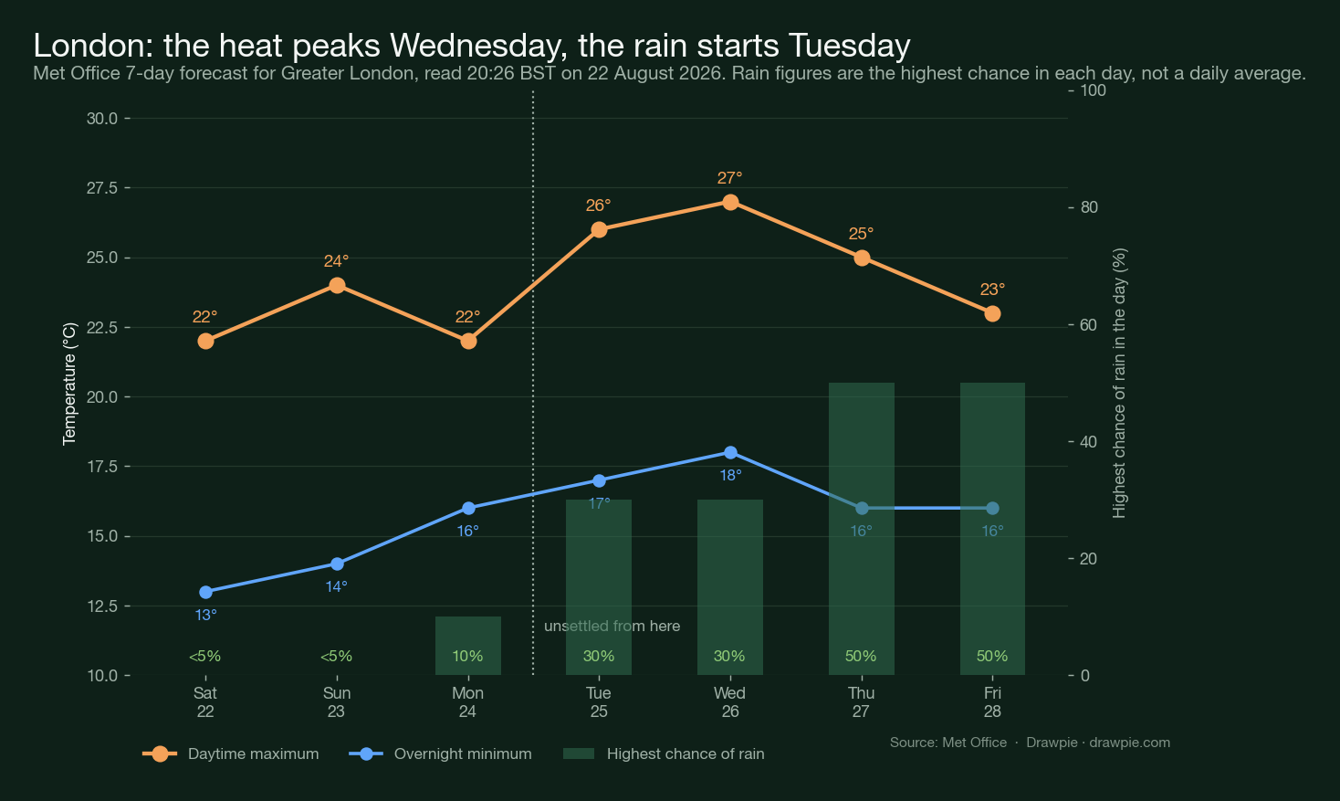
| Day | Max | Overnight low | Conditions | Highest chance of rain |
|---|---|---|---|---|
| Sat 22 Aug | 22C | 13C | Sunny intervals | Under 5% |
| Sun 23 Aug | 24C | 14C | Sunny intervals | Under 5% |
| Mon 24 Aug | 22C | 16C | Sunny intervals | 10% at 10pm |
| Tue 25 Aug | 26C | 17C | Sunny intervals | 30% at 1am |
| Wed 26 Aug | 27C | 18C | Sunny intervals | 30% at 12pm |
| Thu 27 Aug | 25C | 16C | Light showers | 50% at 7am |
| Fri 28 Aug | 23C | 16C | Light showers | 50% at 7am |
Two things worth reading off that table. The overnight minimum climbs all week, from 13C on Saturday night to 18C by Wednesday — that is what makes a warm spell feel like one, more than the daytime figure. And the rain probability steps up rather than ramping: under 5%, under 5%, 10%, then 30%, 30%, 50%, 50%.
These are Greater London figures. Nothing in this table is a national number.
When do the thunderstorms arrive?
From Tuesday, on the Met Office’s wording, and they are part of a broader breakdown rather than an isolated event.
The extended outlook is blunter: “showers or longer spells of rain are possible across many parts of the UK. Some heavy bursts and thunderstorms are likely at times.” That runs into early September, with rainfall “probably above average for the time of year” and “the potential for some stronger winds at times”.
If you want a single sentence for the fortnight: warm and dry through Monday, then changeable, wetter than usual for late August, with thunder in the mix.
Are there any Met Office weather warnings?
No. Not one, for any day from Saturday 22 August to Friday 28 August.
This is worth stating plainly because a forecast mentioning thunderstorms and a warning about thunderstorms are different things, and headlines tend to blur them. The Met Office’s warnings page has a tab for each of the next seven days and all seven currently read “No warnings”.
That can change quickly. Thunderstorm warnings are usually issued a day or two ahead, not a week, precisely because the storms are hard to place until they are close. If one is issued for midweek it will not contradict anything here — it will be the system doing what it does.
Is the UK really getting 29C this week?
Not according to any Met Office forecast read for this page.
The national text gives no figures. London, which is normally the warmest part of the country, tops out at 27C on Wednesday. Nothing in the seven-day London forecast reaches 29C at all.
That is a check of one location and the national text, not a survey of every station in Britain, so this is not a claim that nowhere will see 29C. But if a 29C figure is circulating for this week, it is not coming from the Met Office’s published forecast, and the gap between “a model run suggested it” and “the Met Office forecasts it” is where most overheated weather coverage lives.
For context on what this summer actually delivered: the heat that peaked on 13 August reached 38.1C at Kew Gardens, the fifth-highest temperature ever recorded in the UK. Twenty-seven is a pleasant late-August Wednesday. It is not a heatwave, and the Met Office is not calling it one.
Why has the rain kept not arriving?
Because it is the hardest part of the forecast, and the Met Office has said so itself.
In its 13 August assessment the agency noted that “several forecast systems have previously suggested wetter weather only for the rain to weaken or fail to materialise as expected”, and that confidence in rainfall remains lower than in temperature. That was written about a different week, but the caveat is structural rather than about that particular system.
There is a second problem even when the rain does show up. Much of it moves through quickly, and on ground this dry a lot of it runs off rather than soaking in. What the drought areas need is prolonged, steady rain, which is not what a line of thundery showers delivers.
What about the rest of the summer and into September?
Changeable. The Met Office expects the unsettled theme to continue at first, with showers or longer spells of rain across many areas, “perhaps heavy and thundery in places”, before drier weather possibly becomes more prevalent later in September, especially in the south and southeast.
Temperatures are expected to be near normal at first and possibly warmer later, with the chance of some hot spells in the south. Our September forecast page goes through that outlook in more detail, including why the Met Office’s own monthly forecast stops partway through the month.
Will it be hot this weekend?
Warm rather than hot. Sunday is the better of the two days — settled, largely dry, sunny spells — and in London it reaches 24C against Saturday’s 22C. The Met Office describes Sunday nationally as “largely fine and dry with sunny spells”.
When does the weather change?
Tuesday 25 August. Monday is the last of the fine, dry days in the current run; from Tuesday the Met Office has showers, thunderstorms and longer spells of rain pushing northwards across the country.
Is this a heatwave?
No. A UK heatwave has a formal definition based on three consecutive days at or above a county-specific threshold, and a 27C Wednesday between cooler days does not meet it anywhere. The Met Office is not using the word for this week, and neither is this page.
Sources
| Source | Used for |
|---|---|
| Met Office: UK national forecast | Every quoted forecast line — tonight, Sunday, the Monday-to-Wednesday outlook and both extended periods. Read 20:26 BST, 22 August 2026 |
| Met Office: London (Greater London) forecast | The seven-day temperature, conditions and chance-of-rain table, and the 27C Wednesday peak |
| Met Office: UK weather warnings | That no warnings are in force for any day from 22 to 28 August 2026 |
| Met Office: 10-day trend, 13 August 2026 | The agency’s own caution about rainfall forecasts failing to materialise, and the mid-August heat for context — not used for current conditions |
| Drawpie: UK September forecast | The month-ahead outlook and the limits of the Met Office monthly forecast |
How we verified this
🔴 No Met Office forecast read for this page reaches 29C, and the headline was changed to the figure that is actually there. The national forecast text publishes no numbers at all. The Greater London seven-day forecast, read at 20:26 BST on 22 August 2026, peaks at 27C on Wednesday. London was checked specifically because it is typically the warmest part of the UK; that is a check of one location, not a survey of all of them, and this page does not claim nowhere in Britain will see 29C — only that the official forecast we read does not say so.
🔴 The warnings check is a positive finding, not an absence of research. The Met Office UK warnings page carries a tab per day and every one of the seven from 22 to 28 August reads “No warnings”. A thunderstorm forecast and a thunderstorm warning are different things, and only the first exists right now.
⚠️ Two Met Office blog posts that rank highly for this search are out of date and were not used for current conditions. The “10-day trend” post is dated 13 August and describes the heatwave that peaked that day at 38.1C in Kew Gardens. The “Week ahead: turning fresher with showers, rain and the risk of thunderstorms” post is dated 18 August, and its “Tuesday” and “Wednesday” mean 18 and 19 August — the week that has just finished, not the one ahead. Reading either as current would put the thunderstorms a week early.
✅ Every London figure comes from the Met Office’s own page rather than an aggregator, and the snapshot is committed as data/met-office-london-2026-08-22.json so the chart and the table cannot drift apart from each other. The chart script asserts the 27C peak and fails the build if any day reaches 29C.
⚠️ The rain percentages are not daily averages. The Met Office publishes the highest chance of rain during each day and the hour it applies to. Wednesday’s “30% at 12pm” means the wettest hour of Wednesday carries a 30% chance, not that Wednesday is 30% likely to be wet.
Times and dates are UK local (BST). The forecast was read on the evening of Saturday 22 August 2026.