UK Heat Wave Predictions: What the Met Office Forecast Says for Late 2026
The Met Office prints 28.09.2026 as the next issue date of its 3-month Outlook, and every probability and driver quoted here comes from the 01.09.2026 issue. The long-range page rolls forward daily, so the two window quotes have a shorter life than that and should be re-read before the Outlook is.
Everything else on the page is unaffected; the figures below still say when they were read.

- No UK heatwave is being forecast. The Met Office’s 3-month Outlook states in its own text that it is unable to predict specific heatwaves or prolonged periods of hot weather, and the word heatwave does not appear on its long-range page. Anything firmer than that is somebody else’s writing, not a forecast.
- Daily maximum temperatures — the only thing a heatwave can actually be measured against — are published five days ahead. Past that you get sentences, then probabilities.
- A UK heatwave needs three consecutive days at or above a county threshold of 25, 26, 27 or 28°C, and those thresholds are pegged to mid-July, so an autumn spell is being judged against a midsummer bar.
- What the Met Office does say: warmer than normal. The autumn is ‘around twice as likely to be warm’ than its 1991–2020 baseline, and 20 to 29 September is expected to turn ‘increasingly warm and perhaps rather humid’.
Nobody is forecasting a UK heatwave, and the Met Office has written down why it cannot. Its 3-month Outlook says in plain text that it “is unable to predict specific heatwaves or prolonged periods of hot weather”, and the word heatwave does not appear anywhere on its long-range page. What it does say is narrower and more useful: this autumn is around twice as likely to be warm as its own baseline, and late September looks like turning warm and humid. Here is exactly how far ahead anyone can see, what the current outlook actually says, and what a spell would have to do to count as a heatwave at all.
Is another UK heatwave forecast?
No. There is no official forecast of a UK heatwave for late 2026, and the absence is not an oversight — it is a limit the Met Office states about its own product.
Its 3-month Outlook for September to November puts it this way: “the timing, duration and intensity of any warm spells cannot be determined this far in advance, therefore the Outlook is unable to predict specific heatwaves or prolonged periods of hot weather and cooler periods are also likely.”
That sentence is worth reading twice, because it rules out exactly the thing a headline wants. Warm spells: plausible, and the Outlook says so. A named heatwave on a given week: not something the forecast can produce, at any confidence, at this range. If you see a date attached to a UK heatwave prediction beyond about a week out, it did not come from the Met Office.
How far ahead can a heatwave actually be predicted?
About five days — because that is as far as anyone publishes the one number a heatwave is defined by. The UK definition runs on daily maximum temperatures, and daily maxima simply stop being published after the five-day forecast.
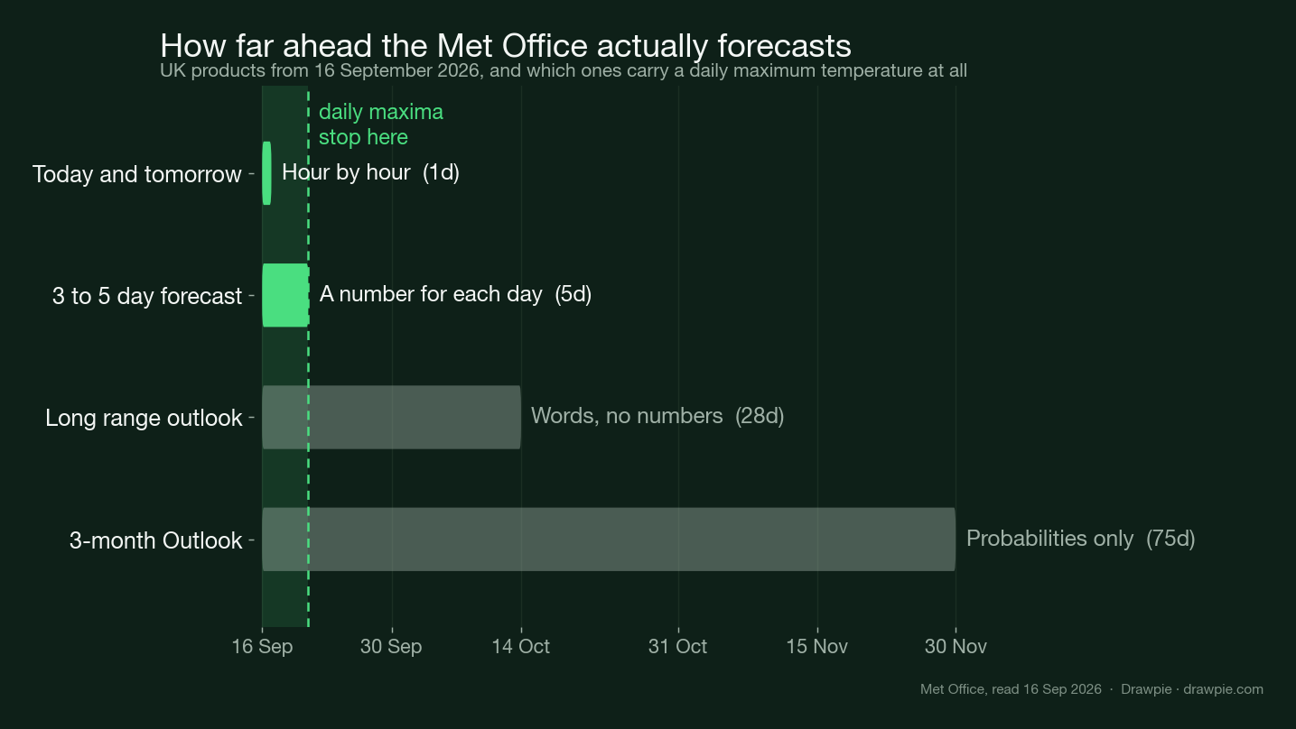
| Product | Ahead | What you get |
|---|---|---|
| Today and tomorrow | 1 day | Hour by hour |
| 3 to 5 day forecast | 5 days | A number for each day |
| Long range outlook | 28 days | Words, no numbers |
| 3-month Outlook | 75 days | Probabilities only |
The step down that matters is between rows two and three. Inside five days you get a figure you can hold against a threshold. Past it, the Met Office switches to sentences — “increasingly warm”, “near average” — which are honest but cannot be tested against a number. Past a month, it switches again, to probabilities for a whole three-month block. Neither of those last two can tell you whether three particular days in a row will clear a particular temperature, which is the only question the heatwave definition asks.
What does the Met Office long-range outlook say right now?
Warmer, and settled first. The current long-range text, issued at midday on 15 September, covers two blocks and neither of them uses the word heatwave.
For 20 to 29 September, it expects a build of pressure across much of the UK, with Atlantic fronts confined to the north and northwest, and says “plenty of dry and increasingly warm and perhaps rather humid weather will develop”. Rain and possible strong winds are more likely in the northwest. It also allows for the opposite: low pressure moving in from the Atlantic and bringing “more widely unsettled conditions” towards the end of the month.
For 30 September to 14 October, it expects more changeable weather, with the west and northwest most likely to be wet and windy, and deep low pressure systems bringing “occasional periods of very strong winds”. Temperatures, it says, are “likely to remain above normal overall”, with brief cooler interludes possible.
So: above normal, not hot. That is a real signal, and it is not the same claim as a heatwave.
What would a late-September spell have to hit to count?
Three consecutive days at or above the threshold for that county, and those thresholds run from 25°C to 28°C.
| Threshold | Roughly where |
|---|---|
| 25°C | Scotland, Wales, Northern Ireland, northern England, the far southwest |
| 26°C | Welsh borders, parts of the Midlands and Yorkshire, parts of southwest England |
| 27°C | Much of southern and eastern England |
| 28°C | Greater London and a few neighbouring counties |
There is a detail buried in how those numbers were set that changes how you read any autumn warm spell. The thresholds come from the 1991–2020 climatology of daily maximum temperature taken at the mid-point of meteorological summer, 15 July. They are a midsummer bar, and they do not move with the calendar.
A late-September spell is therefore being measured against mid-July. Twenty-six degrees in London in September is genuinely unusual for the date and would feel remarkable — and it would still be two degrees short of the capital’s threshold, on any one day, before you even start counting to three. That gap is the main reason autumn spells get called heatwaves in headlines and not by the Met Office.
Does the three-month outlook predict a heatwave?
It predicts a tilt, not an event. The Outlook deals in three categories — warm, near average and cool — and it assigns probabilities to each rather than forecasting weather.
The first thing to get right about those probabilities is the baseline, because it is not thirds. The Outlook states that the near-average category “has a normal likelihood of 60%” and each outer category “has a normal likelihood of 20%”. Against that, a raised warm probability means considerably more than it would against an assumed 33/33/33 split — which is how these outlooks are usually misread.
On that basis the Met Office’s own summary is that the next three months are “around twice as likely to be warm compared to the 1991-2020 reference period”, and that there remains “an increased chance of hot spells during the early autumn”. Then comes the sentence quoted at the top of this page, ruling out anything more specific. Both halves are the forecast. Quoting only the first half is how “twice as likely to be warm” turns into a heatwave headline.
Why does El Niño appear in a UK autumn forecast?
Because the Outlook lists it as one of four drivers, and this one is unusually strong. The document describes “a very strong El Niño event, that is likely to be historic within the modern recorded era and which is likely to persist until at least early 2027”.
The other three drivers it names are the warming of the UK climate in line with global trends, higher than normal sea-surface temperatures near the UK, and the effect El Niño has on northwest Europe — which the Outlook says increases the chances of wetter, stormier conditions through autumn and early winter.
That last point cuts against the heat story rather than for it, and it is why the outlook’s autumn is warm and unsettled rather than warm and dry. The Met Office adds that this El Niño has made the seasonal pattern more consistent across prediction systems than usual, which gives “a somewhat greater degree of confidence in the seasonal forecast for this autumn” — confidence in the tilt, still not in any particular week.
Where should you check, and when?
Two pages, on two different clocks. The long-range outlook rolls forward daily, so it is the one to re-read if you are planning something a fortnight out. The 3-month Outlook moves roughly monthly: the current issue is dated 1 September and the Met Office prints 28 September as the date of the next one.
If you want a number rather than a sentence, there is only one place to get it, and that is the five-day forecast for your own location. Everything longer is a description of the odds. Our companion piece tracks how the Met Office’s September wording has shifted week by week , which is a useful check on how much these outlooks move; and if the warm spell does arrive, cooling a room without air conditioning is the practical half of the problem.
The bottom line
The honest answer to “when is the next UK heatwave” is that no forecaster will tell you, because none of them can at this range, and the Met Office has said so in writing. What is on the record is a warm tilt: an autumn around twice as likely to be warm as the baseline, a late-September stretch expected to turn increasingly warm and humid, and October temperatures likely to stay above normal. None of that is a heatwave, and the distance between the two is measured in whole degrees and three consecutive days.
How we verified this
Sources and dates. Read on 16 September 2026. The two long-range window quotes come from the Met Office’s own UK forecast page, stamped 12:00 UTC on Tue 15 Sep 2026. Every probability, driver and the “unable to predict specific heatwaves” sentence come from the Met Office 3-month Outlook for September–November 2026, issue date 01.09.2026, next issue 28.09.2026. The heatwave definition and the county thresholds come from the Met Office’s own explainer page and its published threshold map.
The key quote was compared back to the source text, not to our own earlier page. The Outlook’s sentence reads, in full: “the timing, duration and intensity of any warm spells cannot be determined this far in advance, therefore the Outlook is unable to predict specific heatwaves or prolonged periods of hot weather and cooler periods are also likely.” It is quoted here from the PDF’s own text, not from a summary of it.
The 20/60/20 baseline is the Outlook’s, and it is not thirds. The document states that the near-average category “has a normal likelihood of 60%” and that each outer category “has a normal likelihood of 20%”. That is why “around twice as likely to be warm” is the Met Office’s own phrase rather than a ratio we computed — describing these bands as terciles would understate the signal.
The chart’s numbers are derived, not typed. Every bar length, day count and tick date in the forecast-horizon figure is computed from one anchor date and the published window end dates, and the script asserts the result before writing the file. The window dates are transcribed from the live pages and the script’s own header records which reading they came from.
What is deliberately absent. No predicted temperature for any date beyond the Met Office’s own five-day numbers, because none is published. No date for a next heatwave, because no forecaster issues one. No third-party long-range outlets are quoted; where their numbers differ from the Met Office’s, the difference is their model, not new information.