Southern U.S. Heat Wave Forecast: Temperatures, Heat Alerts & When It Will End
Heat alerts are reissued daily. Almost every alert described here expires on the evening of Monday 24 August, and the National Weather Service will decide the next set on Tuesday morning from its own afternoon forecast package. The alert table on this page is a snapshot of what was in force on 24 August, not a standing list.
Everything else on the page is unaffected; the figures below still say when they were read.

- Dallas-Fort Worth reached 109°F on Sunday 23 August, breaking the 1952 record of 107°F and running 14°F above the 1991-2020 normal. It was the largest departure of any major southern city that day.
- There were 59 heat alerts in force across the country on Monday. 22 of them covered the South and 36 the Desert Southwest and California — and that split is the story, because the southern ones expire far sooner.
- Every Extreme Heat Warning in the South ends on Monday evening. Only three Heat Advisories, all from the Austin/San Antonio office, run past that, and they expire on Wednesday 26 August.
- The heat is not ending so much as relocating. The National Weather Service in Fort Worth expects the upper ridge to settle west over the Desert Southwest from Wednesday, and Phoenix is forecast to reach 116°F that day while Dallas falls back to 103°F.
- The Southeast is not in this event. Atlanta ran 5°F above normal on Sunday and Birmingham 2°F, against 14°F at Dallas-Fort Worth.
Dallas-Fort Worth hit 109°F on Sunday and broke a record that had stood since 1952. That was 14°F above the normal high for the date, the largest departure of any major city in the South. On Monday the National Weather Service had 59 heat alerts in force nationally, 22 of them across the southern states.
And yet the answer to “when will it end” is sooner than the numbers suggest — for most of the South, Monday evening. What follows is what has actually been issued, what the forecast offices themselves say happens next, and why Arizona is about to get hotter as Texas cools.
Which areas are under heat alerts right now?
Nine states, with Extreme Heat Warnings concentrated in Texas and Oklahoma. The table below gives the highest level of heat alert in force in each state on Monday 24 August, and the latest local time any of them runs to. Texas alone was covered by warnings from five different forecast offices.
| State | Highest alert | Expires |
|---|---|---|
| Texas | Extreme Heat Warning | Wed 26 Aug, 7PM |
| Arkansas | Heat Advisory | Mon 24 Aug, 8PM |
| Louisiana | Heat Advisory | Mon 24 Aug, 8PM |
| Oklahoma | Extreme Heat Warning | Mon 24 Aug, 8PM |
| Florida | Heat Advisory | Mon 24 Aug, 7PM |
| Arizona | Extreme Heat Warning | Sat 29 Aug, 8PM |
| California | Extreme Heat Warning | Sat 29 Aug, 8PM |
| Nevada | Extreme Heat Warning | Fri 28 Aug, 8PM |
| New Mexico | Heat Advisory | Mon 24 Aug, 8PM |
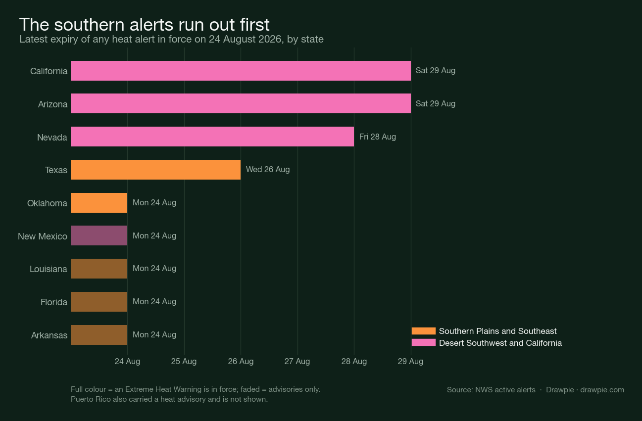
The first five rows are southern states; the last four are the Desert Southwest, and the gap between the two blocks is the whole point of this page.
The warnings quoted the highest numbers in Oklahoma and north Texas: heat index values up to 112 in central Oklahoma, up to 111 across North and Central Texas, and air temperatures up to 113 in the South Plains around Lubbock.
The Norman office went further in its own forecast discussion, putting a 20 to 30 percent chance on highs reaching 112 to 115°F south of Interstate 40 on Monday. It also supplied the context that makes that number legible: a daily high of 115°F has been recorded three times at Wichita Falls since 1923, and once at Lawton since 1912.
How hot did it actually get?
109°F at Dallas-Fort Worth, which beat the previous record of 107°F from 1952. Oklahoma City reached 101°F and San Antonio 103°F. Phoenix reached 113°F, one degree short of its own record for the date.
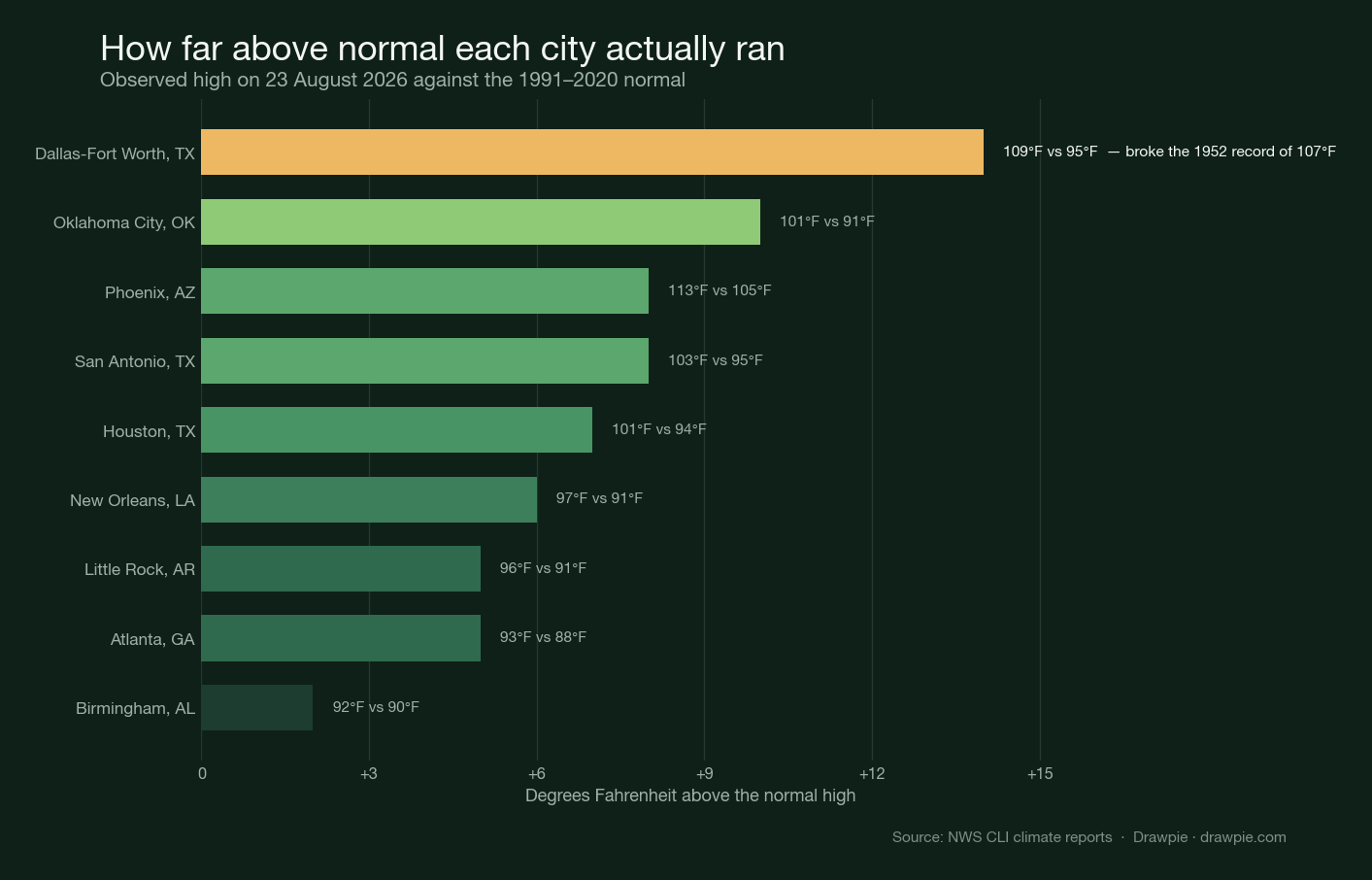
Departures matter more than raw numbers here. 101°F in Houston is 7°F above normal; 113°F in Phoenix is 8°F above normal. The Phoenix figure is the more extreme temperature and the less extreme anomaly.
When will the Southern heat wave end?
For most of the South, on Monday evening. Every Extreme Heat Warning in the southern states expires between 7pm and 9pm local time on 24 August. The only southern alerts that run longer are three Heat Advisories from the Austin/San Antonio office, which expire on Wednesday 26 August.
That is not the same as the heat ending. The Fort Worth office expects highs of 102 to 112 through Tuesday, then a drop from Wednesday into the weekend as the pattern adjusts — but it is explicit that most locations stay hot and dry. Alerts are reissued daily, and Fort Worth said outright that heat headlines would likely be needed again on Tuesday.
The forecast highs show the shape of it. Dallas goes 108, 106, 103 and then sits at about 101°F for the rest of the week. Oklahoma City gets a sharper break, from 107°F on Monday to 94°F by Wednesday, before climbing back to 102°F by Sunday.
Oklahoma’s break has a cause you can point at: a cold front sliding southeast across the north of the state on Monday, followed by a weak surface high on Wednesday. The Norman office puts Thursday as the day with the least coverage of heat headlines all week — and then warns that the warming resumes into the following weekend. Nothing in either office’s discussion describes the pattern as breaking down. It slackens for about forty-eight hours.
Why does the heat move west as Texas cools?
Because the ridge causing it moves, and the Fort Worth office says so in its own discussion. The heat is being driven by a mid-level ridge centred near southern New Mexico, with sinking air beneath it and downslope southwesterly winds compressing and warming the air as it comes off the Rockies.
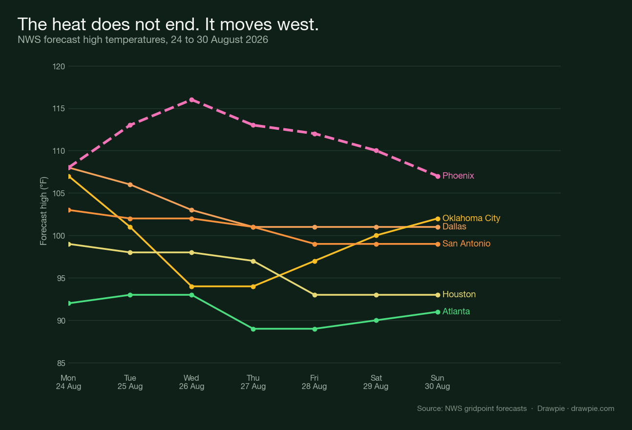
From Wednesday that ridge axis settles farther west over the Desert Southwest. That is why Phoenix is forecast to climb to 116°F on Wednesday while Dallas falls, and why the Arizona and California warnings run to Saturday rather than expiring with the southern ones. Fort Worth also notes the ridge may try to expand back east late in the weekend — which is the honest caveat on any “it ends Wednesday” reading.
Is the Southeast in this heat wave?
Not really. Atlanta ran 5°F above normal on Sunday and Birmingham 2°F. Atlanta’s forecast highs for the week are 92 to 93°F, which is an ordinary late August in Georgia. The single southeastern alert was a Heat Advisory for the Florida Panhandle, for heat index values up to 110, and it expired Monday evening.
Houston sits between the two. It reached 101°F on Sunday, was under a Heat Advisory on Monday for a peak heat index of 106 to 110, and drops to 93°F by Friday.
What does the heat index actually mean?
It is what the temperature feels like once humidity is accounted for, and the National Weather Service sorts it into four bands. Below is the classification the NWS publishes, which is what the alert thresholds are built on.
- Caution, 80°F to 90°F — fatigue possible with prolonged exposure or physical activity.
- Extreme Caution, 90°F to 103°F — heat cramps, heat exhaustion or heat stroke possible with prolonged exposure or physical activity.
- Danger, 103°F to 124°F — heat cramps or heat exhaustion likely, heat stroke possible.
- Extreme Danger, 125°F or higher — heat stroke highly likely.
Monday’s alerts in Oklahoma and north Texas quoted heat index values of 108 to 113, which sits in the Danger band. You can put your own numbers in with our heat index calculator , which uses the National Weather Service’s published equation.
How dry is it, and does that make the heat worse?
Very dry, and yes. Dallas-Fort Worth has recorded a trace of rain this month against a normal of 1.48 inches. Oklahoma City has had 0.14 inches against 2.64. Little Rock has had 0.03 inches against 2.33.
Dry ground heats faster, because the sunlight that would otherwise evaporate soil moisture goes into raising the temperature instead. The Norman office flagged the consequence directly: worsening drought, afternoon humidity down to 13 to 15 percent, and brief periods of near-critical fire weather along the front on Monday.
What should you do during an Extreme Heat Warning?
Follow the instruction the NWS attaches to the alert itself: drink plenty of fluids, stay in an air-conditioned room, stay out of the sun, and check on relatives and neighbours. Limit strenuous outdoor activity to early morning or evening.
The reason the warnings single out prolonged exposure is that heat illness is cumulative. A 103°F afternoon is survivable for most people; a 103°F afternoon spent working outdoors, after a night that did not cool below the high 70s, is a different proposition. That is why the alerts run to 7pm or later rather than ending at the hottest hour.
How we verified this
message_type=alert returned 11 heat alerts and no Texas at all. The real figure is 59, because 49 of them currently carry the message type “Update” — including the Extreme Heat Warning covering Dallas-Fort Worth. The filter manufactured an absence. The pipeline now applies no message-type filter and records the counts so the omission cannot come back silently.
✅ The observed temperatures are from NWS Daily Climate Reports for a completed day, not from a partial one. The newest report for a station sometimes summarises the current day, which at San Antonio meant a “high” of 84°F recorded at 12:22 AM. Only reports for 23 August were accepted, and each one was required to be internally consistent: observed minus normal had to equal the departure the product itself prints.
⚠️ Memphis is missing from the comparison, and that is a data gap rather than an editorial choice. Its climate report for 23 August carries “MM” — missing — in the observed maximum column, so there is no figure to compare. It is left out rather than filled in.
⚠️ Rainfall totals distinguish a trace from a zero. Dallas-Fort Worth’s month-to-date figure is “T”, meaning rain fell but less than a hundredth of an inch. Reporting that as 0.00 would be close to right and still misleading, so the distinction is kept.
⚠️ The forecast temperatures are the National Weather Service’s own gridpoint forecasts, and they are forecasts. They were retrieved on 24 August and will be revised. The heat index figures quoted from alerts are the values the issuing office expected, not measurements.
🔴 No prediction-market prices or betting odds appear anywhere on this page. That is a site-wide rule and it applies to weather as much as anything else.