What Triggered the Catastrophic Nepal-Tibet Border Flood

- A glacial collapse and debris flow, about 13.6 km upstream of the Rasuwagadhi border crossing at 08:37 local time on 26 August 2026. The water reached the crossing roughly twenty-three minutes later.
- There was no earthquake. The magnitude 4.4 quake being reported as a possible trigger was the USGS’s own first, automatic reading of the collapse itself, and the agency has since withdrawn it in those words.
- The revised entry is a magnitude 5.2 landslide at zero depth, marked as reviewed, with its position estimated from satellite images rather than from seismometers alone.
- The death toll was still rising as this was written and the published figures disagreed sharply, so no count appears here as a settled number. Hundreds of people, including foreign trekkers, were unaccounted for.
The question has an answer, and it is not the one most coverage is carrying.
A wall of ice and rock collapsed into a river channel on the Nepal-Tibet border on the morning of 26 August 2026, and the water that came down the Bhote Koshi gorge destroyed villages, border infrastructure and hydropower sites on the Nepali side. Hundreds of people, many of them trekkers, were unaccounted for.
Reports through the day attributed the collapse to a magnitude 4.4 earthquake. There was no earthquake.
What actually triggered the flood?
A glacial collapse and debris flow, at 08:37 local time, about 13.6 km upstream of the Rasuwagadhi border crossing. The US Geological Survey has determined this from its own seismic and satellite data, and has said so in plain terms.
The seismic signal it produced was large — magnitude 5.2 — which is why instruments picked it up at all and why the first automatic reading mistook it for an earthquake. Big mountain collapses shake the ground. They register on seismometers the same way a quake does, and it takes a closer look at the shape of the waves to tell the two apart.
That closer look has now happened.
Was there an earthquake or not?
No. The USGS has withdrawn its own initial report, and the wording is unambiguous. In the Key Points on its event page, updated at 18:44 UTC on 26 August, the agency states that the event was initially reported as a magnitude 4.4 earthquake, that further analysis of nearby seismic stations, long period seismic waves and satellite imagery led to the determination that the signal came from a glacial collapse and debris flow — and that no earthquake had occurred.
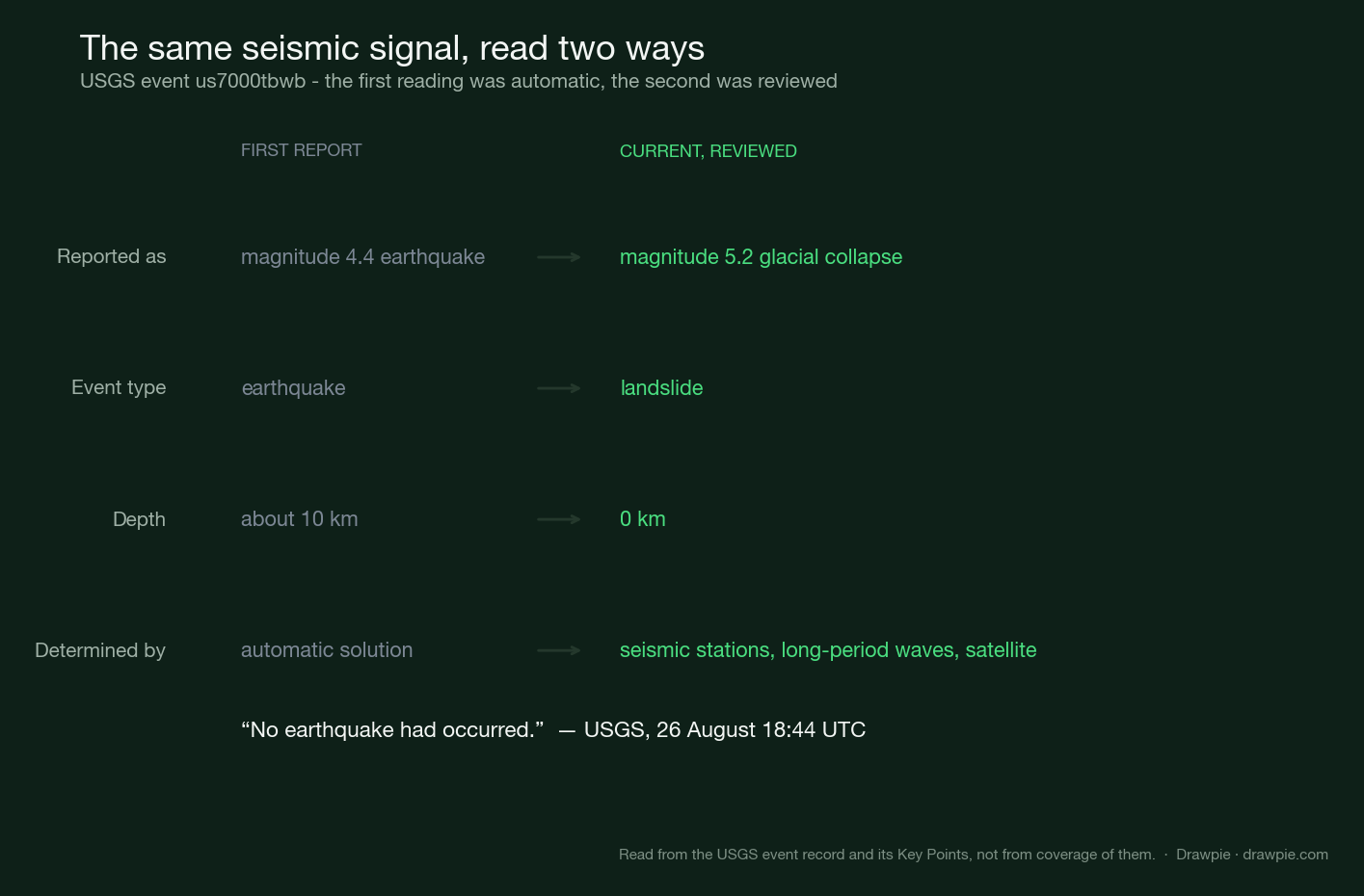
Four things changed between the two readings. The magnitude went up, not down. The depth went to zero, which is what you would expect from something happening on the surface rather than inside the crust. The event type changed from earthquake to landslide. And the position stopped being an instrumental estimate and became one derived from satellite images.
We checked whether a separate earthquake might exist alongside it. Searching the USGS catalogue for anything of magnitude 2 or above, across three days and a box roughly 660 km wide centred on the flood, returns exactly one event — this one. There is no magnitude 4.4 earthquake in the record to be found.
Why did the earthquake story spread?
Because the first reading was public, fast and wrong, and the correction arrived after the news cycle had already set. This is a normal and largely unavoidable sequence, not a scandal.
Automatic seismic solutions exist to be fast. They classify an incoming signal within minutes so that tsunami warnings and emergency responses can begin, and they are revised as human analysts and more data arrive. Most of the time the revision moves a decimal point. Occasionally, as here, it changes what the event was.
The awkward part is the reasoning it left behind. Several outlets noted, correctly, that a magnitude 4.4 earthquake seems too small to bring down a mountainside — and treated that as a puzzle. It is not a puzzle. The signal was never a cause looking for an effect. It was the effect.
How much warning was there?
Twenty-three minutes, and no mechanism to deliver it. The collapse registered at 08:37. The water reached Rasuwagadhi at around nine.
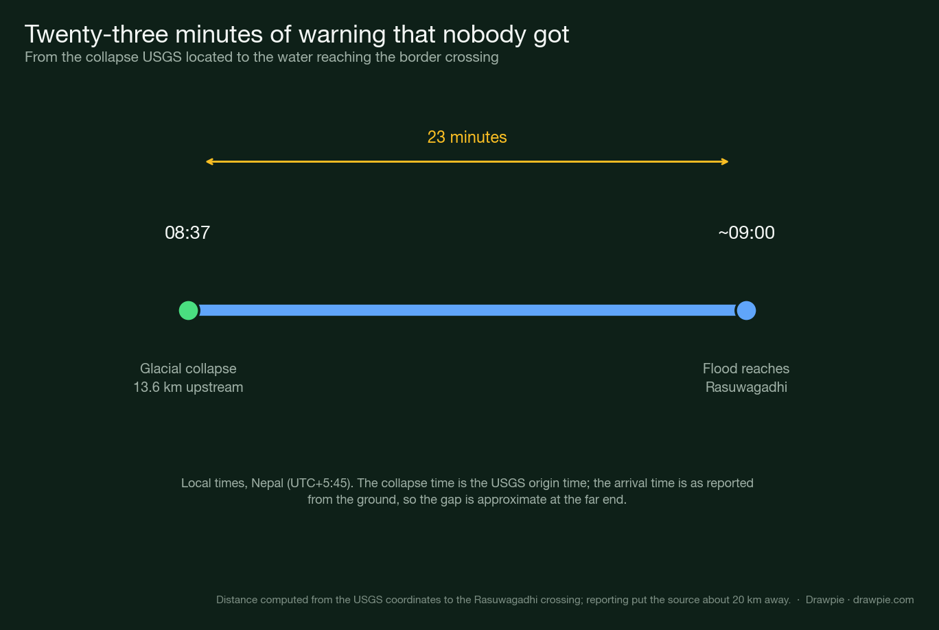
That is the number worth sitting with. A seismometer somewhere recorded the collapse as it happened. The people in its path had a little over twenty minutes, and no way of knowing.
Glacial hazard monitoring in high mountain regions is thin, and this stretch of border is remote even by Himalayan standards. Detecting a collapse is not the hard part — it happened automatically, in real time, and the record exists. Turning that detection into a warning that reaches a village downstream in under twenty minutes is a different problem, and it is not solved here.
What is still unknown?
Why the ice and rock came loose in the first place. The seismic record establishes what the signal was. It does not establish what released the slope.
Reports from the ground describe a temporary debris dam forming across the Lhende Khola and then failing, which would explain the sudden wall of water rather than a steady rise. Nepali and Chinese authorities are working through satellite data together to reconstruct the sequence. That reconstruction has not been published.
The human figures were also still moving as this was written. Published death tolls disagreed by an order of magnitude within a single day, and hundreds of people — Nepali border staff, customs workers, and foreign trekkers on a popular route — were listed as out of contact rather than confirmed either way. Those numbers will have changed by the time you read this, and the places to check are Nepal’s disaster authority and its tourism board rather than any article, including this one.
What will not change is the sequence: something gave way on a mountain at 08:37, it was big enough to shake the ground, and the water arrived twenty-three minutes later.
How we verified this
🔴 The central claim on this page comes from the USGS’s own event record, not from reporting of it. Event us7000tbwb was read from the agency’s event page and from its FDSN API on 26 August 2026: type landslide, magnitude 5.2 ms_vx, depth 0.0 km, origin 2026-08-26 02:52:10 UTC, position 28.271°N 85.515°E, review status REVIEWED.
🔴 The withdrawal of the earthquake is the USGS’s own wording, from the Key Points on that page, updated 26 August at 18:44 UTC: the event “was initially reported as a magnitude 4.4 earthquake”, and further analysis of nearby seismic stations, long period seismic waves and satellite imagery led to the determination that the signal came from “a glacial collapse and debris flow, and that no earthquake had occurred”.
✅ The absence of any earthquake was tested, not assumed. A search of the USGS catalogue for magnitude 2 and above, from 25 to 28 August, across a six-degree box around the flood site — roughly 660 km across — returns exactly one event: this one, typed as a landslide. There is no magnitude 4.4 earthquake in that record at all.
⚠️ The distance is computed here, and it differs from the reported figure. Coverage placed the source “about 20 km” from the Rasuwagadhi crossing. The catalogued USGS position is 13.6 km from it by great-circle distance. Both describe the same event; this page uses the figure that follows from the published coordinates and says so.
⚠️ The twenty-three-minute gap is firm at one end only. The collapse time is the USGS origin time, to the second. The arrival of the water at the crossing is as reported from the ground, around 09:00 local, so the interval is approximate.
🔴 No casualty figure is given as settled, and this is deliberate. Published tolls on the day ran from nine to seventeen to ninety-five within hours, and hundreds of people were unaccounted for. A number printed here would be wrong within hours and could not be corrected as fast as it changed. The scale is described instead.
⚠️ The cause of the collapse itself is a separate question and is not answered here. What released the ice and rock — and whether the temporary debris dam reported upstream formed and failed as described — is still being examined by Nepali and Chinese authorities. This page reports what the seismic signal was, not why the mountain gave way.