UK September Weather Forecast 2026: Heatwave Risk, Rain Outlook and Temperatures
Update log (4)
- — Every forecast quote on this page had been superseded. The Met Office long-range page now carries 'Sunday 13 Sep - Tuesday 22 Sep' and 'Wednesday 23 Sep - Wednesday 7 Oct', so it runs past September entirely and the article's 6-15 / 16-30 September framing is gone, along with the 'confidence is very low' and 'brief warm or very warm spells' lines. The temperature signal has moved back up: 'close to average overall' for the first block, 'a little above average overall' for the second. The word heatwave is still absent. The superseded quotes are kept and labelled, because how this window moves is what the page is about. Two structural fixes: an editorial to-do note — 'Chart must be regenerated…' — had shipped into the live body and is removed, and the page's claim that the long-range text carries no issue timestamp is withdrawn, because the identical text on the main forecast page is stamped 'Updated: 12:00 (UTC) on Tue 8 Sep 2026'. One climate figure corrected: six of the ten warmest UK Septembers have occurred since 2000, not five. The September-November 3-month Outlook is unchanged and still current — issue 01.09.2026, next issue 28.09.2026, with 40/55/5 and 30/55/15 all re-confirmed exactly. No weather warnings were in force for 9-15 September.
- — 2026-09-02: rewritten. The Met Office long-range page now covers 6–15 September and 16–30 September, so the article's central claim that nothing was published for 17–30 September is no longer true. The September text has been replaced twice over: temperatures are now 'near average' and 'around average overall', and the heatwave sentence is gone. The August–October three-month Outlook has been replaced by the September–November issue, dated 1 September, which prints 40% warm / 55% near average / 5% cool and 30% wet / 55% near average / 15% dry — a reversal of the rain signal that also reverses what the outlook implies for the drought.
- — The Met Office has softened its September temperature line. Where the block read 'temperatures are likely to be above average overall' on 18 August, it now reads 'a little above average overall'. It has also added that the month 'looks like it will start rather unsettled', and the window has moved on again — the September text now runs to 16 September rather than 15, leaving 17 to 30 September with nothing published. The heatwave sentence is unchanged. One further thing worth knowing if you are reading the page yourself: it is not rewritten once a day. Its first block changed both its period and its prose within thirty minutes on 19 August.
- — The Met Office long-range forecast now runs to 15 September rather than 14, and its September block has been rewritten. It now states that the north and northwest will probably see the lion's share of the rain and any strong winds, while the south and southeast see the driest and sunniest weather — wording that was not on the page on 16 August. The temperature and heatwave sentences are unchanged, and nothing has been published for 16 to 30 September.
The long-range page rolls forward daily and the next 3-month Outlook is dated 28.09.2026; by 1 October every forecast quote here is superseded and the piece becomes a record of a month that has happened.
Everything else on the page is unaffected; the figures below still say when they were read.

- The Met Office now covers all of September. Its long-range page carries two blocks — 6 to 15 September, and 16 to 30 September — where three weeks ago the second half of the month had nothing published at all.
- The temperature line has been softened twice. In mid-August the September block said temperatures were ’likely to be above average overall’; the current blocks say ’likely to be near average’ for 6 to 15 September and ’likely to be around average overall’ for 16 to 30 September.
- For 6 to 15 September it expects ‘an unsettled period’, with rain ‘most frequent across northern and western areas’ and ’the potential for some strong and gusty winds, particularly in the northwest’. For 16 to 30 September it expects a changeable start turning drier, with the distribution of rain ‘uncertain at this range’.
- The word heatwave is still absent from the long-range page. As of 8 September the temperature signal reads ‘close to average overall’ to 22 September and ‘a little above average overall’ to 7 October. Anything firmer than that is somebody else’s writing.
- The window has now walked past September entirely — it runs to 7 October — so ’the Met Office forecast stops on the 16th’ is no longer the story this page was originally about.
- The page moves more than once a day. Its first block changed period and prose within thirty minutes of our first reading on 19 August, and the window has now ended on the 14th, the 15th and the 16th on three different days.
- A normal UK September is 12.93C, 90.9mm of rain and 127.5 hours of sun on the 1991–2020 baseline. That matters, because ‘above average’ means something different against the 1961–1990 figure of 12.20C.
The Met Office’s long-range forecast now runs past September altogether — to 7 October — and the temperature signal has ticked back up.
This page has tracked that window as it moved. It once stopped on 16 September, with nothing published for the rest of the month. As of 8 September it carries two blocks — “Sunday 13 Sep – Tuesday 22 Sep” and “Wednesday 23 Sep – Wednesday 7 Oct” — so September is no longer the edge of anything. The window has walked past it.
The summary is undramatic and has warmed slightly since our last read: “close to average overall” for the first block, “a little above average overall” for the second. The word heatwave is still absent from the page, as it has been since mid-August.
What does the Met Office actually say about September?
⚠️ The two blocks quoted below are the 2 September state and have both since rolled off the page. They are kept because this page’s subject is how the window moves, and because the quotes below are what a lot of still-circulating September coverage was written from. For what the Met Office says today, see the section above.
The current blocks, read 8 September 2026, are “Sunday 13 Sep – Tuesday 22 Sep” (temperatures “close to average overall”) and “Wednesday 23 Sep – Wednesday 7 Oct” (“a little above average overall”). The “confidence is very low” phrasing and the “brief warm or very warm spells” line quoted below are both gone.
✅ And one thing this page said was impossible has become possible. It reported that the Met Office publishes no issue timestamp for the long-range text. The identical text on the main forecast page is stamped — “Updated: 12:00 (UTC) on Tue 8 Sep 2026” — so the freshness of a given reading can now be pinned down after all.
Here are both blocks as we retrieved them on 2 September 2026 — superseded, kept for the record. First, “Sunday 6 Sep - Tuesday 15 Sep”:
“An unsettled period is likely, with many places seeing showers or longer spells of rain at times. Rain will likely be most frequent across northern and western areas, while the south and east are more likely to see some drier interludes. There is also the potential for some strong and gusty winds, particularly in the northwest. Temperatures are likely to be near average, although brief warm or very warm spells are possible, especially in the south.”
And “Wednesday 16 Sep - Wednesday 30 Sep”:
“Confidence is very low from mid-September onwards. A changeable pattern, with the wettest conditions in the northwest, will likely transition towards more in the way of settled or dry spells between weather systems. The distribution of rainfall is uncertain at this range, but drier conditions than earlier in the month are likely for most. Temperatures are likely to be around average overall, although some warm spells are possible, particularly in the south.”
Read the hedges, because they are the content. “It looks like”. “Signals … soon become weak”. “Becoming most likely”. “Will probably”. “A chance that … hot spells or heatwaves develop”. This is a forecast written by people who are telling you how much they do not know.
Two things have dropped out since mid-August, and they are the ones worth noticing. The temperature sentence has gone from “above average overall” (18 August) to “a little above average overall” (19 August) to “near average” now. And the heatwave sentence — “a chance that late season hot spells or heatwaves develop” — has gone from the page entirely.
Why did it stop on 16 September — and why doesn’t it now?
Because the window moves with you. The long-range forecast looks out about 30 days from the day you read it. On 19 August, 30 days out was the middle of September; on 2 September it reaches 30 September, which is why the whole month is now inside the window. Nothing was added to the forecast — the calendar caught up with it.
| Period | Status, as at 8 September 2026 |
|---|---|
| 9–12 September | Covered by the standard forecast, not the long-range page |
| 13–22 September | Long-range block: temperatures “close to average overall” |
| 23 September – 7 October | Long-range block: “a little above average overall” |
| 28 September | Date the Met Office prints for its next 3-month Outlook |
⚠️ No Met Office weather warnings were in force for 9–15 September at the time of this update.
It is not rewritten once a day, either. We read the page twice on 19 August, thirty minutes apart. The September block was identical both times. The first block was not: at 11:52 BST it was headed “Sunday 23 Aug - Tuesday 1 Sep” and described a period starting “largely dry and settled”; at 13:22 BST it was headed “Monday 24 Aug - Wednesday 2 Sep” with different prose. If you are checking this page against a news story, check the date range in the heading first.
The Met Office is candid about why it will not go further, and about why even the part it does publish is written for the whole country rather than your town:
“when looking at forecasts beyond five days into the future the chaotic nature of the atmosphere starts to come into play … whilst we can still forecast the general feel of the weather to a relatively high level of accuracy using our ensemble models, it becomes harder to offer local detail”
So what about the second half of September?
It is now covered — and the Met Office’s first words about it are “confidence is very low”.
What the Met Office publishes for that fortnight is one paragraph, and it hedges in every clause: a changeable pattern “will likely transition” towards drier spells, the rainfall distribution is “uncertain at this range”, temperatures “likely to be around average overall”.
So there is now a forecast for late September — but it is a direction of travel for the UK as a whole, with the Met Office’s own confidence rating attached. Any article giving a temperature, a date or an “exact day” for late September still has nothing published behind it. That is either a single model run — which changes every six hours and is not a forecast — or it is invention.
Does the three-month outlook say more?
It says something, but it is not a September forecast, and it is easy to misread in two separate ways.
The Met Office publishes a 3-month Outlook for contingency planners. The August–October issue this article originally covered has been replaced: the current one covers September, October and November 2026 and carries an issue date of 01.09.2026 and a printed next issue date of 28.09.2026. It is a three-month average, so September is still not broken out on its own — the outlook’s numbers describe the autumn, not the month.
Chart must be regenerated with the September–November 2026 figures: temperature 5 / 55 / 40 (cool / near average / warm), precipitation 15 / 55 / 30 (dry / near average / wet), wind 15 / 70 / 15 (calm / near average / windy), against the 20/60/20 normal baseline. Alt text to be rewritten to match.
Normal is 20% for each outer band and 60% for near average, so:
| Category | Chance | vs normal |
|---|---|---|
| Warm | 40% | 2.0× |
| Near average | 55% | 0.9× |
| Cool | 5% | 0.3× |
| Wet | 30% | 1.5× |
| Near average (rain) | 55% | 0.9× |
| Dry | 15% | 0.8× |
The first trap: these are not thirds. The Met Office’s own normal likelihoods are 20 / 60 / 20, not 33 / 33 / 33. If you assume thirds, 40% looks like a mild 1.2×. Against the real baseline it is the 2.0× the Met Office prints — and the outlook says so in words: the next three months are “around twice as likely to be warm compared to the 1991-2020 reference period”.
The second trap: the signal is back-loaded now, not front-loaded. The new outlook keeps an “increased chance of hot spells during the early autumn”, but its summary says “the latter part of the period is the most likely to be wet” and that “the chances of impacts from rain and wind become higher than normal later in the period” — that is late October and November, not September. It also names a driver the August issue did not lean on: “a very strong El Niño event, that is likely to be historic within the modern recorded era”. Read as a September document, it says less than it appears to.
“Close to the climatological norm” — what is normal?
A normal UK September is 12.93°C, with 90.9mm of rain and 127.5 hours of sunshine, on the 1991–2020 baseline.
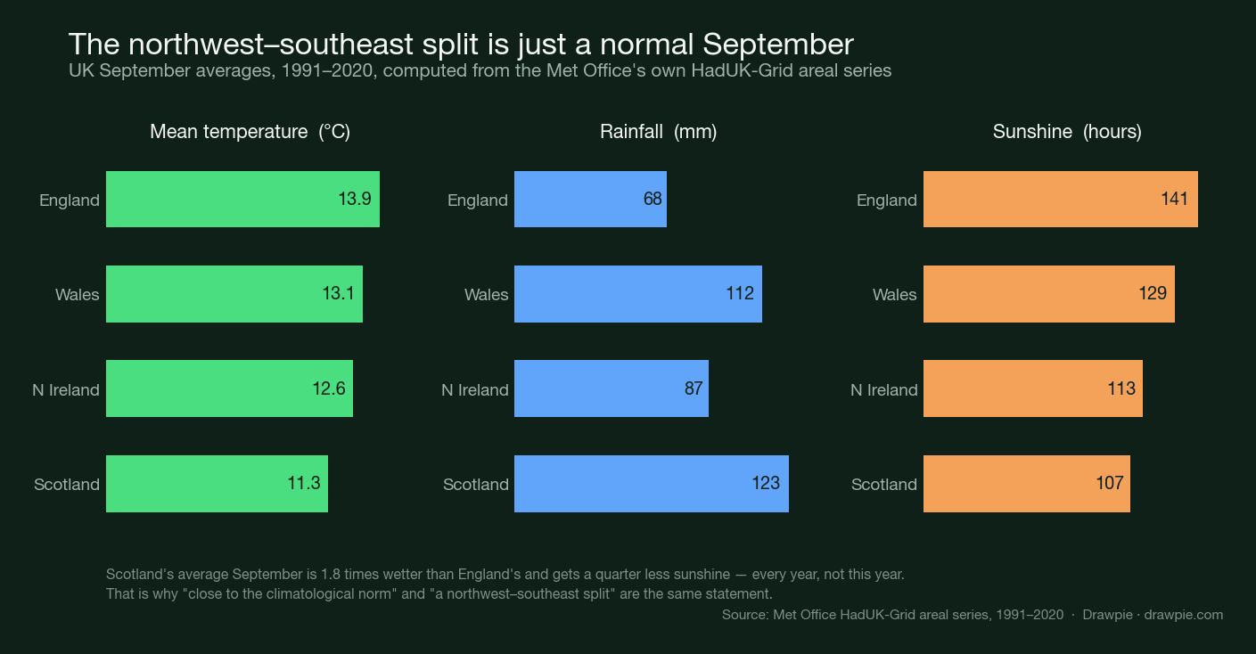
The forecast’s other structural claim is a “broad northwest-southeast split”. That phrase sounds like a forecast of something unusual. It is not — it is a description of what September in the UK is like every year.
| Temp | Rain | Sun | |
|---|---|---|---|
| England | 13.9°C | 68mm | 141h |
| Wales | 13.1°C | 112mm | 129h |
| N Ireland | 12.6°C | 87mm | 113h |
| Scotland | 11.3°C | 123mm | 107h |
Scotland’s average September is 1.8 times wetter than England’s and gets about a quarter less sunshine. So when the Met Office says both “close to the climatological norm” and “a northwest-southeast split”, it is not saying two things. It is saying the same thing twice.
“Above average” temperatures — above which average?
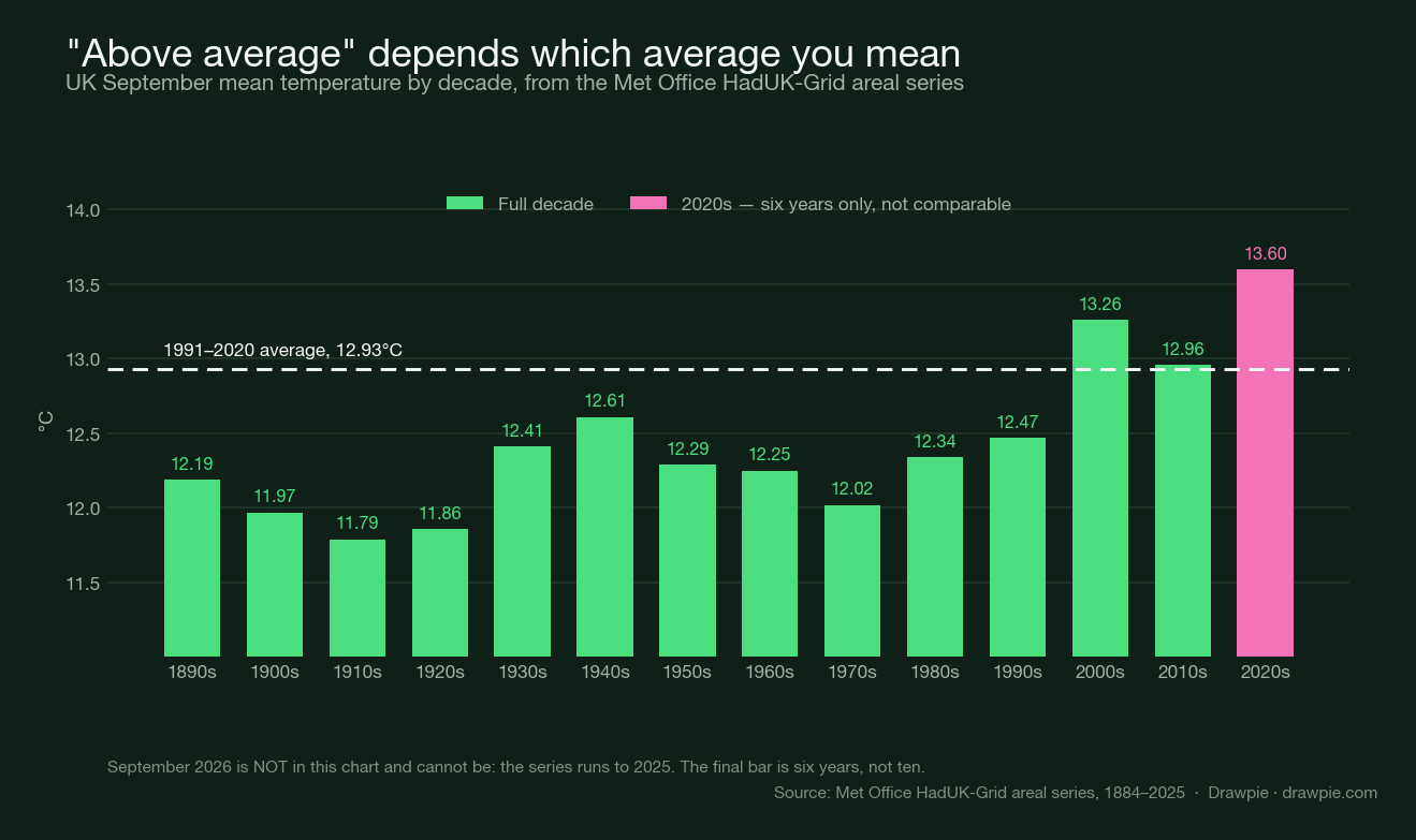
This is where a real number can mislead without anyone lying. The Met Office now says “a little above average overall”, and does not say which average. The 1991–2020 UK September mean is 12.93°C. The 1961–1990 mean is 12.20°C. The most recent thirty years, 1996–2025, average 13.22°C.
| Baseline | UK September mean |
|---|---|
| 1961–1990 | 12.20°C |
| 1991–2020 | 12.93°C |
| 1996–2025 | 13.22°C |
A September that comes in at 13.0°C is “above average” against two of those three and below the third. When you read “above average”, the useful question is not how much — it is against what.
For context on the range: the warmest UK Septembers on record are 2006 and 2023, tied at 15.2°C, and the coldest is 1952 at 9.9°C. Six of the ten warmest have occurred since 2000 — this page said five, and recomputing from HadUK-Grid gives six.
What does it say about rain?
More than it did, and it has moved wetter. The first half of the month now leads with rain rather than with a split:
“An unsettled period is likely, with many places seeing showers or longer spells of rain at times. Rain will likely be most frequent across northern and western areas, while the south and east are more likely to see some drier interludes.”
Watch how far that has travelled. On 16 August the block said only that “drier, more settled weather is slightly more likely towards the south and east”; by 18 August it named “the lion’s share of the rain and any strong winds” for the north and northwest; it now opens by calling the period unsettled outright. The geography has been stable throughout — north and west wet, south and east drier. What has moved is how confidently the Met Office says it will rain.
Two things to take from it, and one not to:
- It is a split, not a total. The forecast says where rain is more likely relative to elsewhere. It does not say how much, on which days, or in which towns — and by design it never will at this range.
- The autumn as a whole now leans wet — but the wet signal sits in late autumn, not September. The September–November outlook now leans wet (30% against a normal 20%), and the Met Office addresses the question directly: “it is too early to say whether rainfall this autumn will provide meaningful drought relief in the areas that have experienced the driest conditions”.
- It is not a rainfall figure. A normal September delivers 90.9mm across the UK on the 1991–2020 baseline, but that is climatology, not this forecast. Nothing published says September 2026 will be wetter or drier than that.
⚠️ The wording has now moved several times: the rain sentence appeared on 18 August, the temperature sentence was softened on 19 August, and by 2 September both blocks had been replaced outright — the heatwave sentence is gone and temperatures read “near average”. If you are reading this well after 2 September, expect it to have moved again. The page carries no issue date and is redrafted more than once a day.
Does any of this mean another heatwave?
No — and the Met Office has now dropped the word from the page. The heatwave sentence that stood in mid-August is gone; the strongest language left is “brief warm or very warm spells are possible, especially in the south”. Its three-month outlook is explicit that it cannot do better: it “is unable to predict specific heatwaves or prolonged periods of hot weather and cooler periods are also likely”.
That is worth holding onto given the summer behind it. As we covered when the August heatwave broke , 2026 had already produced six heatwaves and records at several thresholds before September began. A warm September would not be surprising. But “would not be surprising” is not a forecast, and the Met Office has not issued one.
What about the drought?
The forecast will not answer that question, and this is the part that actually affects people.
By mid-August, all of Wales and around half of England were in official drought status, with hosepipe restrictions covering millions of households. Those restrictions come off on the state of reservoirs and rivers, not on a weather outlook. The Met Office now expects an unsettled first half of September and leans wet for the autumn as a whole — but it is blunt about what that is worth: “even a wet month may only partially alleviate water pressures in parts of the UK, following the prolonged dry weather through the summer”.
If you want to know whether a ban applies to you, your water company’s own page is the authority. We keep a guide to the 2026 hosepipe bans and the areas they cover .
What to check, and when
- For the next week, use the location forecast, not the long-range page. The long-range text is written for the UK as a whole by design and will never mention your town.
- Read the date headings before the words. Both the wording and the period boundaries move, and they move more than once a day — we watched the first block change period and prose inside half an hour.
- Watch for the September–November issue in early September. It is the first product with a September-specific section. The Met Office states only that the Outlook is published monthly and dated the current one 2 August; it does not announce the next date, so this is a cadence inference, not a diary entry.
- Treat anything about 17–30 September as noise for now. No published forecast covers it.
- When you see “above average”, check the baseline. Against 1961–1990 it means something different from against 1991–2020.
- Warnings only run seven days out. There is no such thing as a September weather warning today.
Sources
| Source | What it supports here |
|---|---|
| Met Office long-range forecast | The two forecast blocks and both verbatim quotes, retrieved 13:22 BST on 19 August 2026, with an earlier read at 11:52 BST the same day for the change described above; the accuracy caveat about forecasts beyond five days |
| Met Office 3-month Outlook, September–November 2026 (PDF) | The probability table, the 20/60/20 normal likelihoods, the El Niño driver, the drought and heatwave Q&As, and the 28 September next-issue date |
| Met Office: services for contingency planners | Where the 3-month Outlook is published and when the next issue is due |
| Met Office HadUK-Grid areal series | Every climate figure here: the 1991–2020, 1961–1990 and 1996–2025 baselines, the four-country breakdown, the decadal series and the warmest and coldest Septembers. Computed by us from the published series |
| Met Office: UK climate extremes | The September records referenced for context |
Checked 2 September 2026. No affiliate links, and no payment was received for any link on this page.
How we verified this
The forecast text is quoted from the page as we retrieved it, and stamped with a retrieval time rather than an issue time. We read the Met Office long-range forecast in a browser at 13:22 BST on 19 August 2026 and quote it verbatim. The page carries no issue date anywhere in its HTML — no issuedAt, no lastUpdated, no datePublished — so there is no issue date for us to print. It also carries no year: “Wednesday 2 Sep – Wednesday 16 Sep” is pinned to 2026 by weekday alignment.
The stamp is BST, and earlier versions of this page labelled the same kind of stamp “GMT”. The UK is on British Summer Time in August, so the correct label is BST; the times themselves were right.
It is redrafted more than once a day, which we established by reading it twice. At 11:52 BST on 19 August the first block was headed “Sunday 23 Aug – Tuesday 1 Sep”; at 13:22 BST it was headed “Monday 24 Aug – Wednesday 2 Sep”, with different prose. The September block was word-for-word the same in both reads. Anyone reading this later should expect different words and possibly different dates: across 16, 18 and 19 August the September window has ended on the 14th, the 15th and the 16th, the block gained a sentence naming where the rain would fall, and the temperature sentence was softened from “above average” to “a little above average”.
We verified the page before quoting it. An invented sibling path on the same host returns 404 while the real page returns 200, so a live response there is meaningful rather than a host that answers everything.
The three-month outlook probabilities are not thirds, and calling them thirds would have understated the signal. The Met Office states in the document that the near-average band has “a normal likelihood of 60%” and each outer band 20%. Against that real baseline, 40% warm is the 2.0x the Met Office itself prints. Against an assumed 33/33/33 it would look like 1.2x. The words “tercile” and “quintile” do not appear in the document.
The issue date is now unambiguous, where it was not before. For the August–October issue the Met Office published three different dates — PDF header 27.07.2026, hosting page 2 August 2026, file metadata 22 July 2026 — so we described that one by its period. The September–November issue prints 01.09.2026 in the PDF and “1st September 2026” on the page hosting it, and the two agree, so we use it. (The file’s own PDF metadata still lags, at 26 August 2026.)
The climate figures are computed from the Met Office’s own gridded series, and we found a trap in it. The HadUK-Grid areal files list a year per row, but the final year’s row is short and its fields do not line up with the header. The 2026 row has 10 fields rather than 18, so reading the tenth field as “September” actually returns the spring value, 9.33C — which, being colder than the all-time September record low, would have been published as a record for a month that has not happened. We require a complete 18-field row, which correctly excludes 2026. Every figure here is therefore 1884–2025 only, and nothing in this article is an observation of September 2026.
The media claims here were traced to origin rather than counted. Three outlets quoting the same Met Office update are one source, not three, and in this case the specific edition they quote is not archived anywhere we could reach, so we could not confirm they quoted it accurately. We have described the pattern rather than repeating their numbers.
We are explicit about what we could not check. Several UK outlets refused our requests outright, and Netweather blocked us site-wide — including its own homepage, which voids the test entirely. So where this article says nothing was found, it means nothing was found in the sources we could reach. We are not claiming those forecasters are silent.
Two circulating claims are deliberately absent. A widely-linked “September heatwave verdict” story returns a 404 and its year could not be established, so we neither cite nor rebut it. And the “long-range forecasts are 60–70% accurate” line could not be traced to any Met Office page, so it is not printed.
No September 2026 temperature, rainfall or event is forecast here. The Met Office now covers the whole month, but only in categorical prose with its own confidence rating attached; we quote that and add nothing to it. Inventing a number would be the whole failure mode this article is about.