East Coast Nor'easter: Latest Forecast, Storm Track, Flooding & Wind Impacts
A deadline, set by the products themselves. The Weather Prediction Center’s 72-hour rainfall forecast and its Excessive Rainfall Outlook on this page both run to 8 a.m. EDT Monday 28 September 2026, and the NWS coastal flood and wind alerts drawn here expire by late Sunday. After that the page describes a forecast for a storm that has passed. Rewrite it then as an after-action page from observed data: NWS storm reports for peak gusts and rain totals, and NOAA Tides and Currents for the highest water levels at each gauge, set against the forecasts printed here.
Everything else on the page is unaffected; the figures below still say when they were read.

- An early-season nor’easter is forecast to stall off southern New England. The NWS forecasts gusts near 60 mph on Nantucket and Cape Cod and 55 mph on eastern Long Island, 3 to 4 inches of rain on the Jersey Shore, Long Island and in southeastern New England, and coastal flooding at high tide from Virginia to Massachusetts through Sunday.
- Coastal flooding is the widest threat. Coastal Flood Warnings run from the Outer Banks to Cape Cod, and the full moon at 12:49 p.m. EDT Saturday raises the tides that the storm surge rides on.
- The storm deepened from 1,009 millibars on Thursday morning to 995 on Friday morning. The Ocean Prediction Center forecasts 986 millibars by 8 a.m. Saturday, and a weakening center about 50 miles south of Long Island by 8 a.m. Sunday.
- High Wind Warnings cover the Jersey Shore, the Delaware beaches, most of Rhode Island and eastern Massachusetts. New York City is under a Wind Advisory, with gusts forecast to 45 mph in Lower Manhattan.
A strong nor’easter is forecast to stall off the Mid-Atlantic and southern New England coast, and the worst of it runs from Friday night, September 25, 2026, through Sunday: gusts near 60 mph on Nantucket and Cape Cod and 55 mph on eastern Long Island, 3 to 4 inches of rain on Long Island and in southeastern New England, and coastal flooding at high tide from Virginia to Massachusetts. Every forecast on this page comes from a National Weather Service or NOAA product, as of midday Friday. Those forecasts are reissued several times a day, so check your local NWS office before you act.
Where is the nor’easter now, and where is it going?
Late Friday morning the center was about 200 nautical miles, roughly 230 miles, east to northeast of Cape Hatteras, strengthening as it crept north, according to the NWS Ocean Prediction Center. OPC’s forecast moves it slowly north and northwest toward western Long Island or New Jersey on Saturday night, turns it back to the southwest and south as it weakens on Sunday, then turns it east on Sunday night and moves it off to the northeast from Monday through Tuesday night. The Weather Prediction Center describes a center that will “approach and then stall” off southern New England and the Mid-Atlantic.
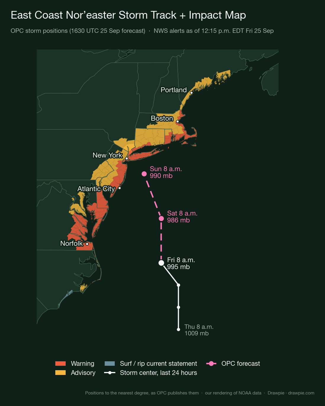
Storm positions from the Ocean Prediction Center’s high seas forecasts, the latest issued 12:30 p.m. EDT Friday; shaded zones are NWS alerts as of 12:15 p.m. EDT Friday. OPC publishes positions in whole degrees of latitude and longitude, so every distance on this page is approximate. This is our rendering of NOAA data, not an NWS graphic.
A falling central pressure is the sign of a strengthening storm. The center dropped from 1,009 millibars on Thursday morning to 995 on Friday morning, and OPC’s 12:30 p.m. high seas forecast deepens it to 986 by 8 a.m. Saturday before it starts to weaken, to 990 by 8 a.m. Sunday, when it puts the center about 50 miles south of Long Island’s south shore. The NWS office in Mount Holly, N.J., wrote on Friday morning that many models bring the center near or even onto the New Jersey coast, though by then, it said, the storm will be weakening considerably.
The Weather Prediction Center explains the cause in its Friday morning discussion: an upper-level trough digging into the eastern US is interacting with cool air that a large high-pressure system is feeding over the still-warm western Atlantic. The Mount Holly office adds that the tightening pressure gradient between the low and the high to the north is what drives the persistent north-to-northeast wind.
The Gray, Maine, office notes that notable coastal floods often come from slow or stalled storms that push surge ashore over several tide cycles. The warnings here stretch across several high tides, from Friday into Sunday.
When will the nor’easter hit my area?
It is already under way from North Carolina to New Jersey, with tidal flooding in Virginia and Delaware since Wednesday, and the peak wind reaches New York and New England from Friday night into Saturday. Rain wraps around the storm through Sunday and lingers in eastern Massachusetts into Monday, and the weakening low moves off to the northeast on Monday and Tuesday.
The local NWS offices put the strongest winds at these times:
- New Jersey and Delaware coast: Friday night through Saturday night (Mount Holly).
- New York City and Long Island: Friday night through Saturday night (Upton).
- Southern New England: Friday night through Saturday morning (Boston).
- Southern Maine and New Hampshire: Saturday into Saturday night (Gray).
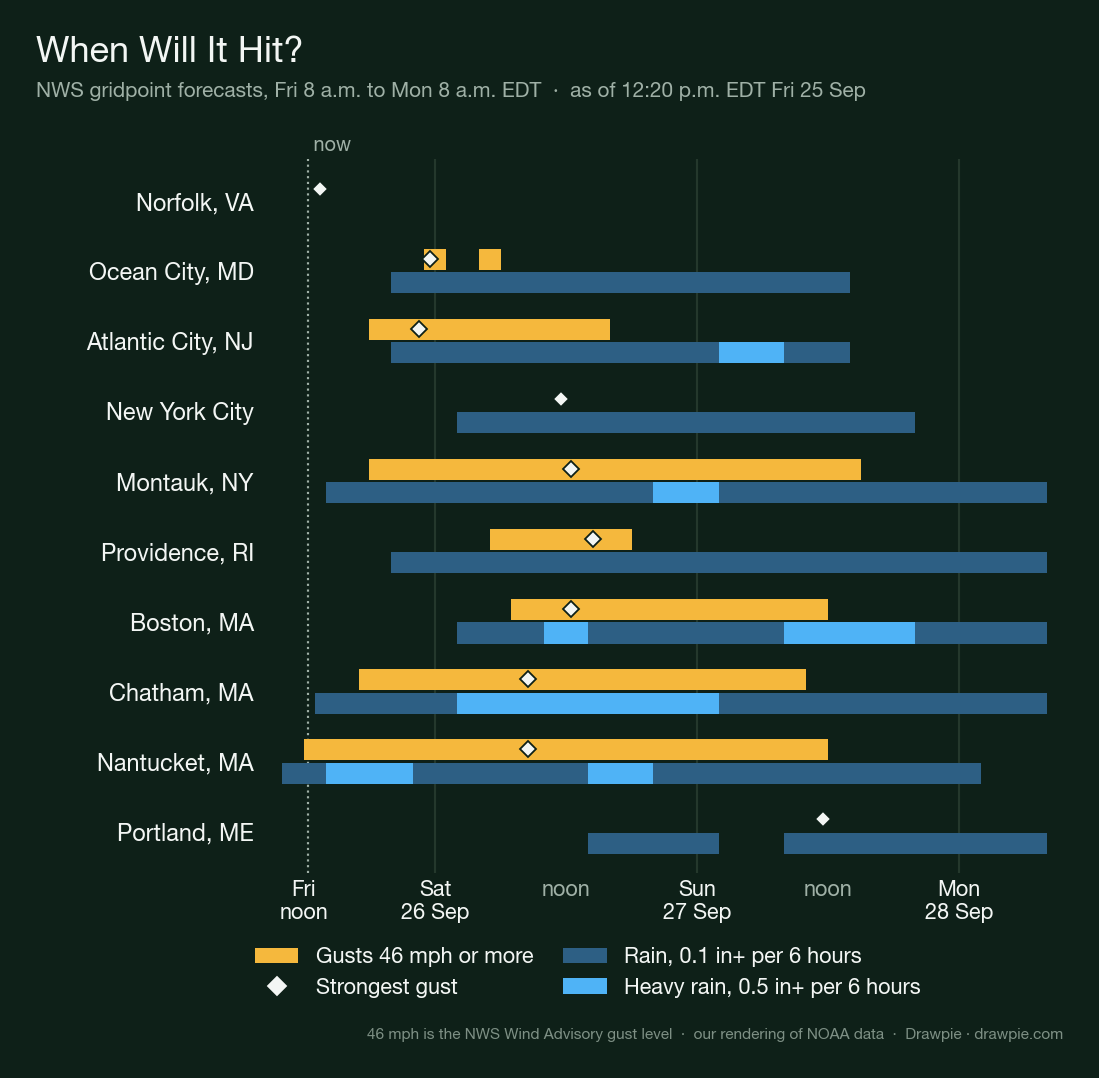
From NWS gridpoint forecasts for each city, Friday 8 a.m. to Monday 8 a.m. EDT. 46 mph is the gust level for an NWS Wind Advisory. Our rendering of NOAA data.
| City | Gusts of 46 mph or more | Heaviest rain |
|---|---|---|
| Norfolk, VA | Not forecast | None forecast |
| Ocean City, MD | Fri 11 p.m. to Sat 5 a.m. | None forecast |
| Atlantic City, NJ | Fri 6 p.m. to Sat 3 p.m. | Sun 2 a.m. to 8 a.m. |
| New York City | Not forecast | None forecast |
| Montauk, NY | Fri 6 p.m. to Sun 2 p.m. | Sat 8 p.m. to Sun 2 a.m. |
| Providence, RI | Sat 5 a.m. to 5 p.m. | None forecast |
| Boston, MA | Sat 7 a.m. to Sun 11 a.m. | Sat 10 a.m. to 2 p.m., Sun 8 a.m. to 8 p.m. |
| Chatham, MA | Fri 5 p.m. to Sun 9 a.m. | Sat 2 a.m. to Sun 2 a.m. |
| Nantucket, MA | Fri noon to Sun 11 a.m. | Fri 2 p.m. to 10 p.m., Sat 2 p.m. to 8 p.m. |
| Portland, ME | Not forecast | None forecast |
What has the storm done so far?
Tidal flooding in Virginia and Delaware since Wednesday, and ocean overwash on the Outer Banks since early Thursday. NWS storm reports logged flooded streets in Norfolk and Suffolk, Va., on Wednesday morning, and gauges at Dewey Beach, Rosedale Beach and Indian River Inlet in Delaware reached moderate flood that evening. North Carolina closed NC 12 on Hatteras Island early Thursday after the ocean washed over it; WTKR, citing the state transportation department, reported a dune breach at the Pea Island Visitor Center and about 500 feet of damaged pavement.
The Outer Banks Voice reported six of seven state ferry routes suspended on Thursday, and an NWS storm report logged NC 12 on Ocracoke closed at 8 a.m. Friday. The strongest gusts reported so far include 55 mph at Avon, N.C., on Thursday evening, and 51 mph at Ocean City, N.J., and 50 mph at Atlantic City on Wednesday. NOAA’s Sewells Point gauge in Norfolk reached 6.0 feet on Thursday night, a moderate flood in preliminary data.
How strong will the wind gusts get?
The strongest forecast gusts are 62 mph on Nantucket, 61 mph at Chatham on Cape Cod and 60 mph at Montauk, all on Saturday. Atlantic City, Boston and Providence are forecast to gust in the low to mid 50s, and Lower Manhattan to 45 mph. Montauk’s 60 comes from the Upton office’s gridded forecast last updated at 2:36 a.m.; its 10:58 a.m. discussion says gusts near 55 mph on the east end.
The warnings put the ceiling at about 60 mph. The Boston office’s High Wind Warning covers coastal eastern Massachusetts, Cape Cod, the Islands and most of Rhode Island, including Providence, until 2 a.m. Sunday with “gusts up to 60 mph”, and it says “power outages are expected”. The Mount Holly office’s warning for the New Jersey coast and the Delaware beaches runs from 6 p.m. Friday to 6 a.m. Sunday, with sustained winds of 30 to 40 mph and gusts up to 60 mph. New York City and Long Island are under a Wind Advisory for gusts up to 55 mph, strongest on eastern Long Island and the south shore.
The Boston office adds a warning about timing: with trees still in full leaf, the risk of tree damage and power outages is higher than if the same storm came a few months later.
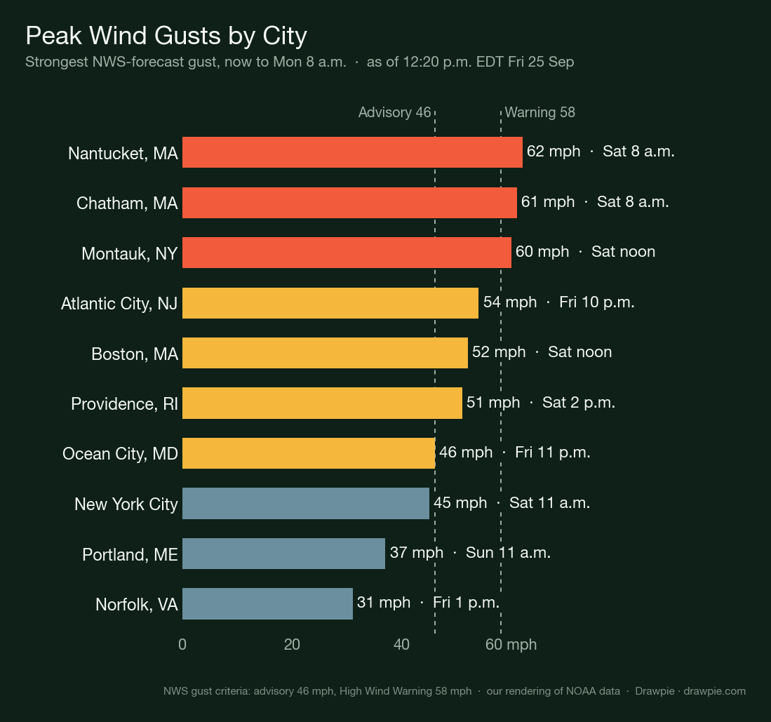
Strongest gust in each city’s NWS gridpoint forecast from midday Friday to Monday 8 a.m. The dashed lines are the NWS Wind Advisory (46 mph) and High Wind Warning (58 mph) gust criteria. Our rendering of NOAA data.
| City | Peak gust | When |
|---|---|---|
| Nantucket, MA | 62 mph | Sat 8 a.m. |
| Chatham, MA | 61 mph | Sat 8 a.m. |
| Montauk, NY | 60 mph | Sat noon |
| Atlantic City, NJ | 54 mph | Fri 10 p.m. |
| Boston, MA | 52 mph | Sat noon |
| Providence, RI | 51 mph | Sat 2 p.m. |
| Ocean City, MD | 46 mph | Fri 11 p.m. |
| New York City | 45 mph | Sat 11 a.m. |
| Portland, ME | 37 mph | Sun 11 a.m. |
| Norfolk, VA | 31 mph | Fri 1 p.m. |
Which areas face which threats?
Coastal flooding is the most widespread threat: a Coastal Flood Warning covers the shore in nine of the eleven regions below, from the Outer Banks to Cape Cod. Damaging-wind warnings are narrower, covering the Jersey Shore and the Delaware beaches, most of Rhode Island, the Boston area and Cape Cod and the Islands. Heavy rain matters most from Long Island to eastern Massachusetts, where the Weather Prediction Center’s flood-risk outlook reaches level 2 of 4.
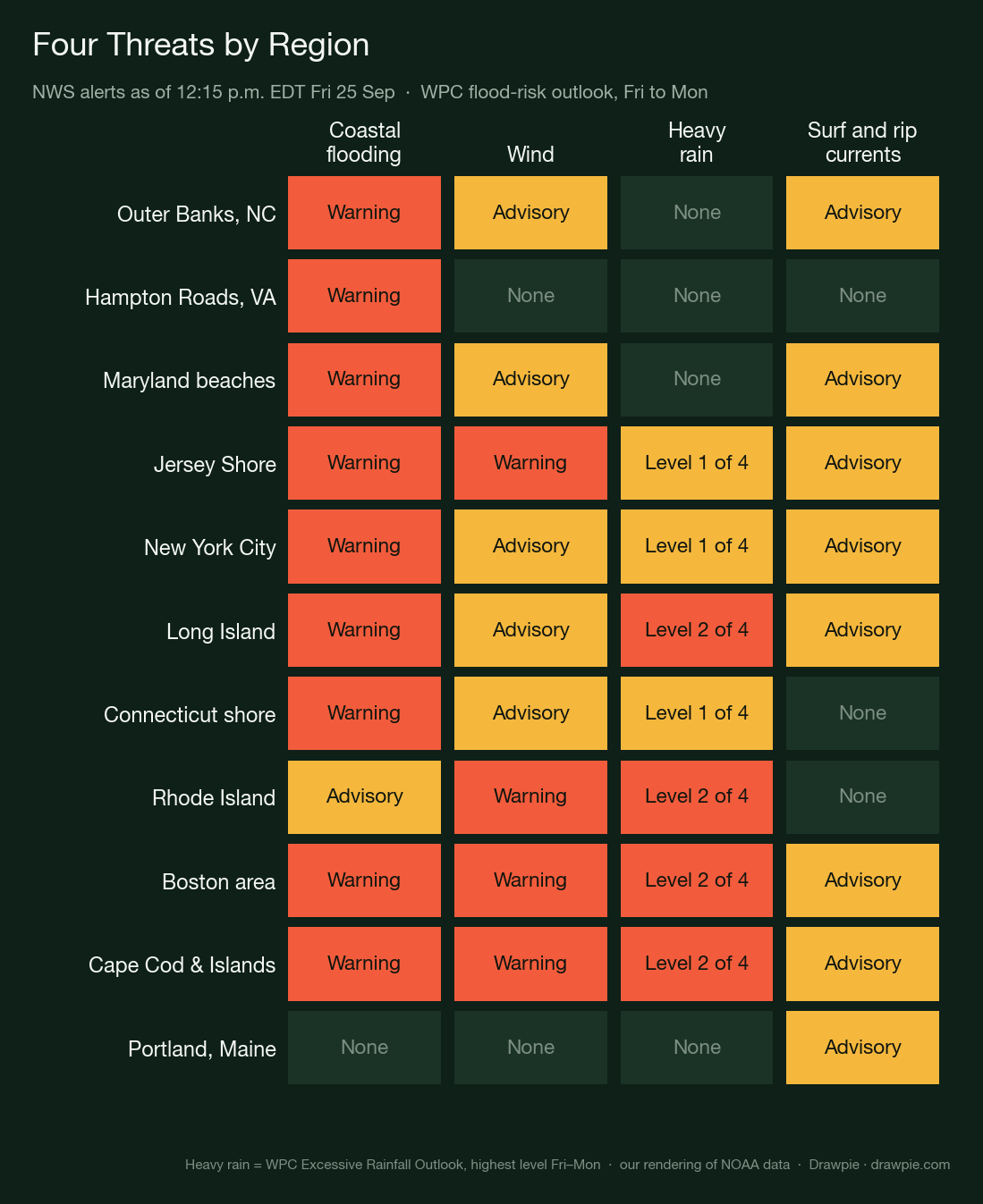
NWS alerts in force or scheduled at a point in each region as of 12:15 p.m. EDT Friday; heavy rain is the highest level of the Weather Prediction Center’s Excessive Rainfall Outlook from Friday to Monday. Our rendering of NOAA data.
When is the coastal flooding worst?
At high tide, from Friday through Sunday, and for New York Harbor and Long Island’s south shore on Saturday morning’s high tide in particular. The NWS forecasts moderate flooding at most gauges from Norfolk to Sandy Hook, major flooding at several Virginia gauges, and moderate to major flooding in parts of New York City and Long Island, and the full moon at 12:49 p.m. Saturday raises the astronomical tide that the storm surge rides on.
What each NWS office forecast in its Friday morning coastal flood products (water levels are feet above mean lower low water, the gauge datum):
- Outer Banks: 2 to 4 feet of water above ground on Hatteras and Ocracoke islands until 11 a.m. Saturday (Newport/Morehead City).
- Virginia and Maryland: warnings run until noon Saturday in Norfolk, Portsmouth, Chesapeake, Suffolk, Hampton and Virginia Beach, where 2 to 3 feet of water above ground is forecast, and until 6 p.m. Saturday along Newport News and the James and York rivers. Sewells Point is forecast at 5.6 feet, moderate, around 9 p.m. Friday and 9 a.m. Saturday; major flooding is forecast at Lynnhaven Inlet at Friday night’s and Saturday morning’s high tides, and at Kiptopeke, Windmill Point, Jamestown and Smithfield. Ocean City Inlet, Md., reaches 5.0 feet, moderate, around 8 a.m. and 8 p.m. Saturday (Wakefield).
- New Jersey and Delaware: 1 to 2 feet above ground. Atlantic City’s highest tide is Friday around 7 p.m. at 7.4 feet, moderate; Sandy Hook reaches 8.0 feet, moderate, around 8 a.m. Saturday. The office “cannot rule out major” flooding in the back bays (Mount Holly).
- New York City and Long Island: the worst flooding comes with Saturday morning’s high tide on the south shore and in New York Harbor, and with the daytime high tides Saturday and Sunday on western Long Island Sound. Major flooding is forecast Saturday morning at Inwood on Jamaica Bay, Freeport, Lindenhurst, West Sayville and Great Kills. The Battery reaches 7.8 to 8.4 feet around 8 a.m. Saturday, minor, and Kings Point 12.0 to 12.5 feet, moderate, around noon Sunday (Upton).
- Massachusetts: minor flooding “with pockets of moderate”, worst south of Boston and on the Cape and Islands, with “severe beach erosion”. Boston Harbor reaches 12.6 to 13.1 feet around noon Saturday, minor (Boston).
- Southern Maine and New Hampshire: a Coastal Flood Advisory for up to 1 foot in coastal York and Rockingham counties from 10 a.m. Saturday to 11 p.m. Sunday (Gray).
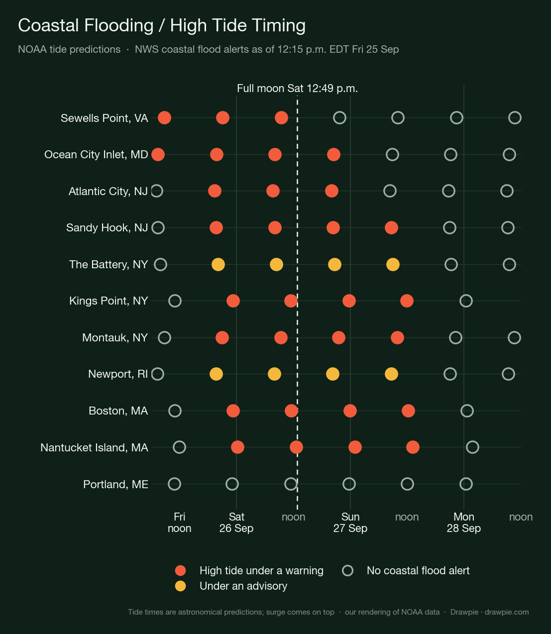
Predicted high tides from NOAA Tides and Currents, colored by whether an NWS Coastal Flood Warning or Advisory is in force at that time. Surge adds to these astronomical tides; the full moon time is from the US Naval Observatory. Our rendering of NOAA data.
| Tide gauge | High tides under a coastal flood alert |
|---|---|
| Sewells Point (Norfolk), VA | Fri 8:45 a.m., Fri 9:01 p.m., Sat 9:23 a.m. (warning) |
| Ocean City Inlet, MD | Fri 7:23 a.m., Fri 7:49 p.m., Sat 8:06 a.m., Sat 8:28 p.m. (warning) |
| Atlantic City, NJ | Fri 7:19 p.m., Sat 7:41 a.m., Sat 8 p.m. (warning) |
| Sandy Hook, NJ | Fri 7:40 p.m., Sat 8:01 a.m., Sat 8:18 p.m., Sun 8:37 a.m. (warning) |
| The Battery, NY | Fri 8:03 p.m., Sat 8:23 a.m., Sat 8:39 p.m., Sun 8:56 a.m. (advisory) |
| Kings Point, NY | Fri 11:11 p.m., Sat 11:23 a.m., Sat 11:44 p.m., Sun 11:56 a.m. (warning) |
| Montauk, NY | Fri 8:54 p.m., Sat 9:18 a.m., Sat 9:32 p.m., Sun 9:55 a.m. (warning) |
| Newport, RI | Fri 7:37 p.m., Sat 7:58 a.m., Sat 8:17 p.m., Sun 8:38 a.m. (advisory) |
| Boston, MA | Fri 11:13 p.m., Sat 11:34 a.m., Sat 11:54 p.m., Sun 12:12 p.m. (warning) |
| Nantucket Island, MA | Sat 12:11 a.m., Sat 12:32 p.m., Sun 12:58 a.m., Sun 1:12 p.m. (warning) |
| Portland, ME | None in the alert window |
How much rain will fall?
Three to four inches from the Jersey Shore and Long Island to Rhode Island and southeastern Massachusetts, in the Weather Prediction Center’s 72-hour forecast from Friday 8 a.m. to Monday 8 a.m., with 4 to 5 inches across central and eastern Long Island, the Monmouth and Ocean County shore in New Jersey, a sliver of southern Rhode Island and parts of southeastern Massachusetts, and more than 5 inches offshore. Among the ten cities below, the local NWS grids forecast the most for Boston, at 4.4 inches, and Chatham, at 4.2.
The local offices’ own ranges are close: 3 to 5 inches for eastern Massachusetts and Rhode Island (Boston), 3 to 4 inches for central and eastern Long Island and 1 to 3 inches elsewhere around New York (Upton), 2 to 4 inches on the northern New Jersey coast (Mount Holly), and 1 to 2 inches from southern New Hampshire into southwestern Maine (Gray).
WPC puts the flood risk at level 2 of 4 over eastern Massachusetts, Rhode Island, southeastern Connecticut and central and eastern Long Island from Saturday morning to Sunday morning, and over eastern Massachusetts and Rhode Island from Sunday morning to Monday morning. Before that, from Friday into Saturday, it is level 1 of 4 on the New Jersey coast, Long Island, the Rhode Island and southeastern Connecticut shore, and Cape Cod and the Islands. WPC calls level 2 a “Slight” risk of rain heavy enough to cause flash flooding; the scale tops out at level 4, “High”. No Flood Watch was in effect from North Carolina to Maine as of midday Friday, and the Upton office called the flash-flood concern “low at this time”.
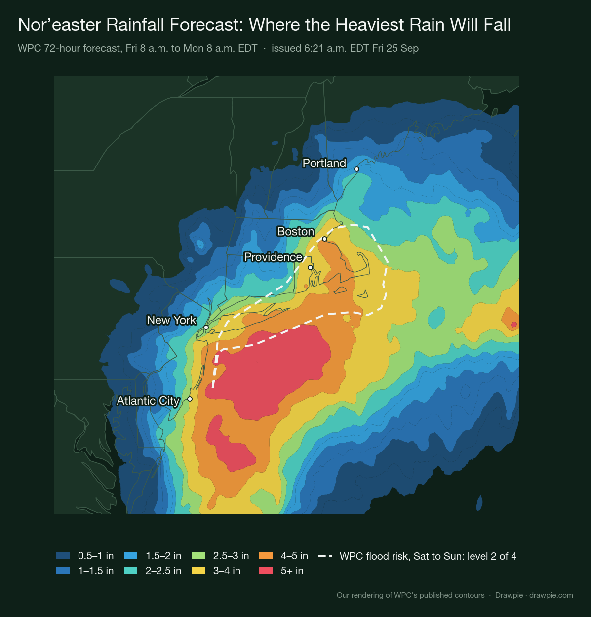
The Weather Prediction Center’s 72-hour forecast, Friday 8 a.m. to Monday 8 a.m. EDT, issued 6:21 a.m. EDT Friday. The dashed line is WPC’s level 2 of 4 flood-risk area for Saturday into Sunday. Our rendering of WPC’s published contours.
| City | WPC 72-hour band | Local NWS total |
|---|---|---|
| Norfolk, VA | 0.1–0.25 in | 0.0 in |
| Ocean City, MD | 1.75–2 in | 1.5 in |
| Atlantic City, NJ | 3–4 in | 2.9 in |
| New York City | 2.5–3 in | 2.4 in |
| Montauk, NY | 3–4 in | 4.0 in |
| Providence, RI | 3–4 in | 3.4 in |
| Boston, MA | 3–4 in | 4.4 in |
| Chatham, MA | 3–4 in | 4.2 in |
| Nantucket, MA | 3–4 in | 3.8 in |
| Portland, ME | 1.75–2 in | 1.8 in |
How big will the waves get?
Breaking waves of 5 to 15 feet at the beach, depending on the stretch of coast, and far bigger seas offshore. The NWS High Surf Advisories forecast 10 to 15 feet on the Outer Banks, up to 12 feet on the Delaware and New Jersey beaches and 13 feet in eastern Monmouth County, 9 to 15 feet on the south shore of Suffolk County, 6 to 13 feet on the east coast of Massachusetts and 7 to 12 feet in southern Maine and New Hampshire, most of them through Saturday or Sunday evening.
The Mount Holly office expects “significant beach erosion” and says “breaching of sand dunes is possible”; the Boston office forecasts “severe beach erosion for a prolonged period”. Offices from North Carolina to New York, and the Gray office in southern Maine and New Hampshire, warn of a high rip current risk.
Is a nor’easter this early in the season unusual?
The NWS calls it an early-season storm. The Upton and Boston offices and the Weather Prediction Center all use that phrase; “rare” is the word in news coverage, not in the forecast products.
The Boston office wrote on Friday that both the high and the low are outside the model climatology of the European and US ensemble forecasts, forecaster shorthand for unusually strong, and the Gray, Maine, office said the storm’s track is a close match for the March 2018 nor’easter, though that storm was much stronger and the astronomical tides then were about a foot higher than this weekend’s. The National Hurricane Center expects no tropical development in the next seven days, so this is not a tropical system.
Why have some forecasts you’ve seen been higher?
Because they are not the NWS forecast, or not the same measurement. Three numbers in circulation this week:
- 4 to 6 inches of rain for Boston and Long Island, in a network news report. The Boston office forecasts 3 to 5 inches and the Upton office 3 to 4 inches for eastern Long Island; WPC’s 72-hour map tops out at 4 to 5 inches on land, on central and eastern Long Island, the northern Jersey Shore, a sliver of southern Rhode Island and parts of southeastern Massachusetts; Boston itself is in its 3 to 4 inch band. A private forecaster has gone as high as 8 inches, with a 13-inch “StormMax”.
- Waves up to 22 feet in New England. That matches the NWS forecast for open-ocean seas, 15 to 25 feet offshore, not waves at the beach, which are 6 to 13 feet in Massachusetts.
- Gusts of 70 mph or hurricane force. On land, the High Wind Warnings say gusts up to 60 mph. The Boston office’s 1:10 a.m. discussion allowed 65 to 70 mph in a few spots on the Islands, but its 2:59 a.m. update topped out at 60; over its coastal waters it forecasts gusts of 45 to 60 knots, about 50 to 70 mph. No NWS product forecasts hurricane-force gusts.
What should you do now?
Plan around the high tides and the Saturday wind peak, and take your local NWS office’s word over any number on this page once it updates.
- Before each high tide in the table above, move cars off streets that flood, and do not drive through water on a road. The NWS rule is “Turn Around Don’t Drown”: it says 12 inches of rushing water can carry away most cars.
- By Friday evening, bring in or tie down anything loose outside and charge phones and battery packs. The Boston office expects power outages where the High Wind Warning is in force.
- Stay off beaches, jetties and seawalls through the weekend. High Surf Advisories and rip current statements run from the Outer Banks to Maine.
- Follow your local officials on closures and any evacuation orders, and look up your own address at weather.gov: its point forecast comes from the same NWS grids as the charts on this page, and it is always the latest version.
How we verified this
🔴 No forecast on this page is ours. Every position, gust, rainfall total, alert, tide time and risk level comes from a National Weather Service or NOAA product, and each chart prints the product and issue time it was drawn from. Where this page does arithmetic — distances from the storm center, the pressure drop, which high tides fall inside an alert window — it says so.
The products, and when each was read (Friday 25 September 2026, EDT):
- Storm positions and pressures: NWS Ocean Prediction Center High Seas Forecasts for the North Atlantic. The track is the analysis position from each issuance over the previous two days, taken from the Iowa Environmental Mesonet’s archive of NWS text products; the forecast points are from the 12:30 p.m. EDT (16:30 UTC) issuance, which replaced a 6:30 a.m. forecast that had the center 3 millibars weaker on Saturday and about a degree farther east on Sunday.
- Wind gusts, rain totals and timing: NWS gridpoint forecasts (api.weather.gov) at one coordinate per city, fetched about 12:20 p.m. Each local office updates its grids on its own schedule, so the ten cities were not all updated at the same minute.
- Alerts: every active NWS alert from North Carolina to Maine as of 12:15 p.m., with no filter on message type, because most live alerts are updates of earlier ones and a filter would silently drop them.
- Rainfall and flood risk: the Weather Prediction Center’s 72-hour forecast (issued 6:21 a.m.) and its Excessive Rainfall Outlook for Days 1 to 3, from NOAA’s public map service.
- Tides: NOAA Tides and Currents predictions for eleven gauges; the full moon time is from the US Naval Observatory.
- Office-by-office detail: each NWS office’s Friday morning coastal flood, wind and surf products and forecast discussions (Newport/Morehead City, Wakefield, Mount Holly, Upton, Boston, Gray), OPC’s 10:57 a.m. offshore forecast for the track beyond Sunday, and NWS storm reports and preliminary NOAA gauge data for what has already happened. Water levels are quoted as each office printed them, with its own flood category.
- Two impact details come from news reports and are credited as such: the NC 12 dune breach (WTKR, citing the state transportation department) and the ferry suspensions (Outer Banks Voice).
⚠️ The “higher forecasts” section names claims, not outlets. The 4 to 6 inch figure is from a network news report of Thursday, the 8 inch and “StormMax” figures from a private forecaster’s Wednesday forecast. We compared them with the NWS and WPC products; the “70 mph” figure traces to the Boston office’s 1:10 a.m. discussion for a few spots on the Islands, which its 2:59 a.m. update dropped to 60, and to its marine forecast in knots; the page says so.
⚠️ “Peak gust” means the forecast at one point, not the highest gust anywhere in that city. The New York City figure is for Lower Manhattan; coastal Brooklyn and Queens can gust higher.
⚠️ Two thresholds on the charts are ours. The 46 mph line is the NWS Wind Advisory gust criterion. The rain shading, 0.1 inch and 0.5 inch per six hours, is our choice for showing when rain falls and when it is heavy; it is not an NWS category.
⚠️ Two sets of rain numbers are shown because they are two products. The map and the “WPC band” column are the Weather Prediction Center’s 72-hour forecast; the “local NWS total” column is the sum of each local office’s gridpoint forecast over the same 72 hours. They usually agree to within a band, and where they differ neither is wrong.
⚠️ Alert status is read at a point on land. Tide gauges sit in the water, often outside every public forecast zone, so each gauge and each region was checked at a nearby land coordinate. Two first attempts landed in marine zones and were moved.
🔴 These are our renderings of NOAA data, not NOAA’s graphics. The maps redraw WPC’s rainfall contours, NWS zone boundaries and OPC’s positions in our own colors over a Natural Earth basemap. Nothing was simplified, but nothing here is an official image; for those, go to weather.gov and wpc.ncep.noaa.gov.
🔴 No betting odds, prediction-market prices or model output appear here, and nothing on this page is a forecast of our own.