Canada Orange Severe Thunderstorm Watch: Areas Affected & What It Means
The Manitoba watch described here was issued at 11:01 PM CDT on Monday 24 August and will be cancelled or upgraded within hours. The zone list is a snapshot, not a standing list. Everything on this page about what orange means, how Environment Canada chooses a colour, and how a watch differs from a warning stays true after the watch lapses.
Everything else on the page is unaffected; the figures below still say when they were read.

- Twenty-four Manitoba forecast zones were under an orange severe thunderstorm watch, issued at 11:01 PM CDT on Monday 24 August 2026. Winnipeg was not among them.
- Orange is the middle of three alert colours Environment Canada now attaches to every warning, advisory and watch. The agency’s own description is blunt: orange alerts are uncommon.
- The colour is not a judgement call. It comes from a published matrix of impact against forecast confidence, and this bulletin states both inputs on its face: impact high, confidence high. That combination is orange.
- The forecast was gusts up to 110 km/h, hail up to ping pong size, locally heavy rain, and an isolated tornado threat with any storm that developed.
- The same Manitoba storm system produced both colours at once. Zones expecting moderate impact got a yellow warning; zones expecting high impact got the orange watch.
- Across all thirteen provinces and territories at that moment, 53 alerts were in force. All 24 orange ones came from this single system, and every other alert in the country was yellow or an uncoloured statement.
Twenty-four forecast zones in Manitoba went under an orange severe thunderstorm watch at 11:01 PM CDT on Monday 24 August, with wind gusts of up to 110 km/h, hail up to ping pong size, and an isolated tornado threat with any storm that formed.
If the word “orange” is the part that stopped you, that is reasonable. Environment Canada only recently began putting colours on its weather alerts, and orange is the one most Canadians have not seen yet. The agency’s own description of it is short: orange alerts are uncommon.
Which areas are under the orange severe thunderstorm watch?
The watch covered 24 forecast zones, all of them in Manitoba, running from the Ontario border west toward the Red River valley and north up the east side of Lake Winnipeg.
The named communities include Steinbach, Niverville and Grunthal in the R.M. of Hanover; Lorette, Ste-Geneviève and Landmark in the R.M. of Tache; Richer in the R.M. of Ste. Anne; Marchand, Sprague, Sandilands, Hadashville, Rennie, Elma and Powerview-Pine Falls; St-Pierre-Jolys and St. Malo; Roseau River in the Municipality of Emerson-Franklin; and Zhoda, Vita and Sundown in the R.M. of Stuartburn. Further north the watch reached Berens River, Bissett, Bloodvein, Little Grand Rapids and Atikaki Provincial Park, Manigotagan, Pointe du Bois, Nopiming Provincial Park, Victoria Beach, Falcon Lake and West Hawk Lake, Pinawa, Lac Du Bonnet, Shoal Lake Reserves, and Buffalo Point.
Winnipeg was not among the 24 zones. The watch wrapped around the city to its east and south without covering it, which is worth saying plainly, because a provincial headline about Manitoba storms invites the assumption that the largest city is included.
What does an orange severe thunderstorm watch mean?
Orange is the middle of three colours. Environment Canada defines it as severe weather that is likely to cause significant damage, disruption or health impacts, with effects that are major, widespread, or may last a few days.
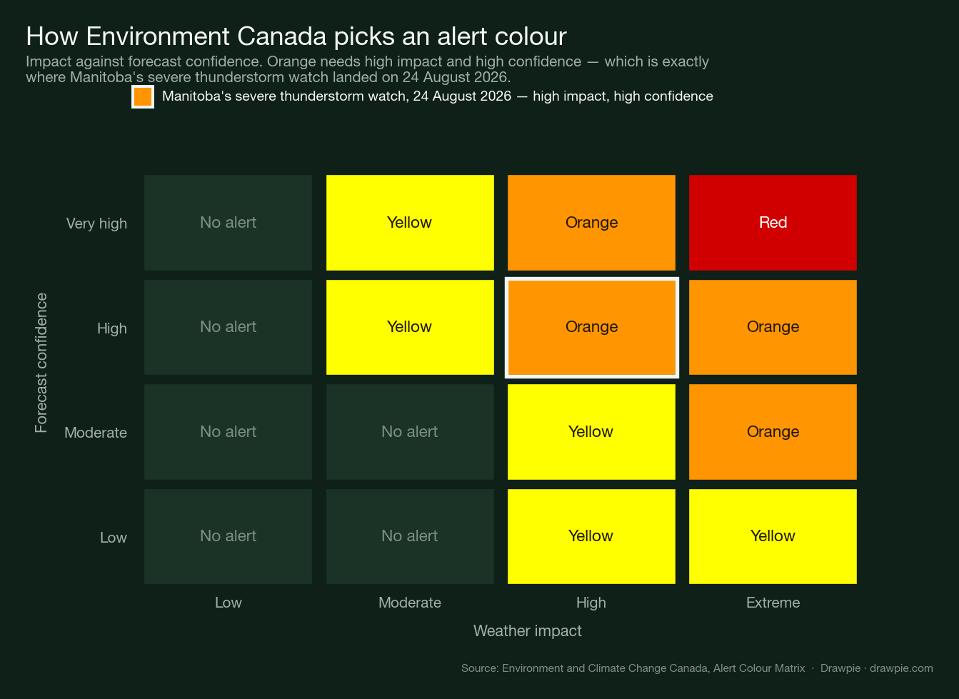
The colour is not a mood or a judgement call. Every bulletin states two things on its face — an Impact Level and a Forecast Confidence — and the colour follows from where those two meet on a published matrix. The Manitoba bulletin read impact high, confidence high. On the matrix, that cell is orange.
How is an orange alert different from a yellow one?
Yellow is the common one: hazardous weather that may cause damage or disruption, with impacts that are moderate, localised or short-term. Orange sits a full step above it, and the step is real rather than rhetorical. Above orange sits red, for very dangerous and possibly life-threatening weather causing extreme damage — rare, and not in force anywhere in Canada on this particular night.
Worth separating from the colours: the alert type is a different axis entirely. Advisories are the third type alongside warnings and watches, reserved for weather that is less severe but still significant, and Environment Canada uses them for things like fog, blowing snow, freezing drizzle and frost. An advisory gets a colour too.
The clearest illustration came from this same Manitoba system, which produced both colours at the same time.
| Alert | Impact | Confidence |
|---|---|---|
| Orange watch | High | High |
| Yellow warning | Moderate | High |
| Yellow watch, Ontario | High | Moderate |
Read down that table and the logic is visible. Forecasters were equally confident about the yellow warning and the orange watch; what separated them was how hard the weather was expected to hit. The Ontario row shows the other axis moving instead: the same high impact, but less certainty, and the colour drops back to yellow.
Why is it a watch and not a warning?
A watch means get ready. Environment Canada issues one when conditions are favourable for severe weather to develop, and says a watch may be upgraded to a warning as certainty increases. A warning means act now, and is usually issued 6 to 24 hours ahead — though for something like a tornado the notice can be under 30 minutes.
There is a second difference that matters for reading a map. Severe thunderstorm and tornado warnings are now targeted: forecasters draw a polygon around the area a specific storm is expected to hit, and can run several at once inside one zone, which is why warnings sometimes appear labelled as storm A and storm B. Watches are still issued across whole forecast zones. That is why an orange watch can cover 24 zones at once while a warning covers a shape a few kilometres wide.
Because the polygons can be split, merged and stacked, the colours can differ within one storm. Environment Canada’s own example is an orange severe thunderstorm warning and a red tornado warning running at the same time over the same ground, each carrying its own safety advice. So the colour on your phone describes the specific threat being alerted, not the storm as a whole.
What weather was actually forecast?
The bulletin was specific. A trough of low pressure moving across southern Manitoba was expected to set off severe thunderstorms, bringing wind gusts up to 110 km/h, hail up to ping pong size, and locally heavy rain. It added that an isolated tornado threat was possible with any storm that developed.
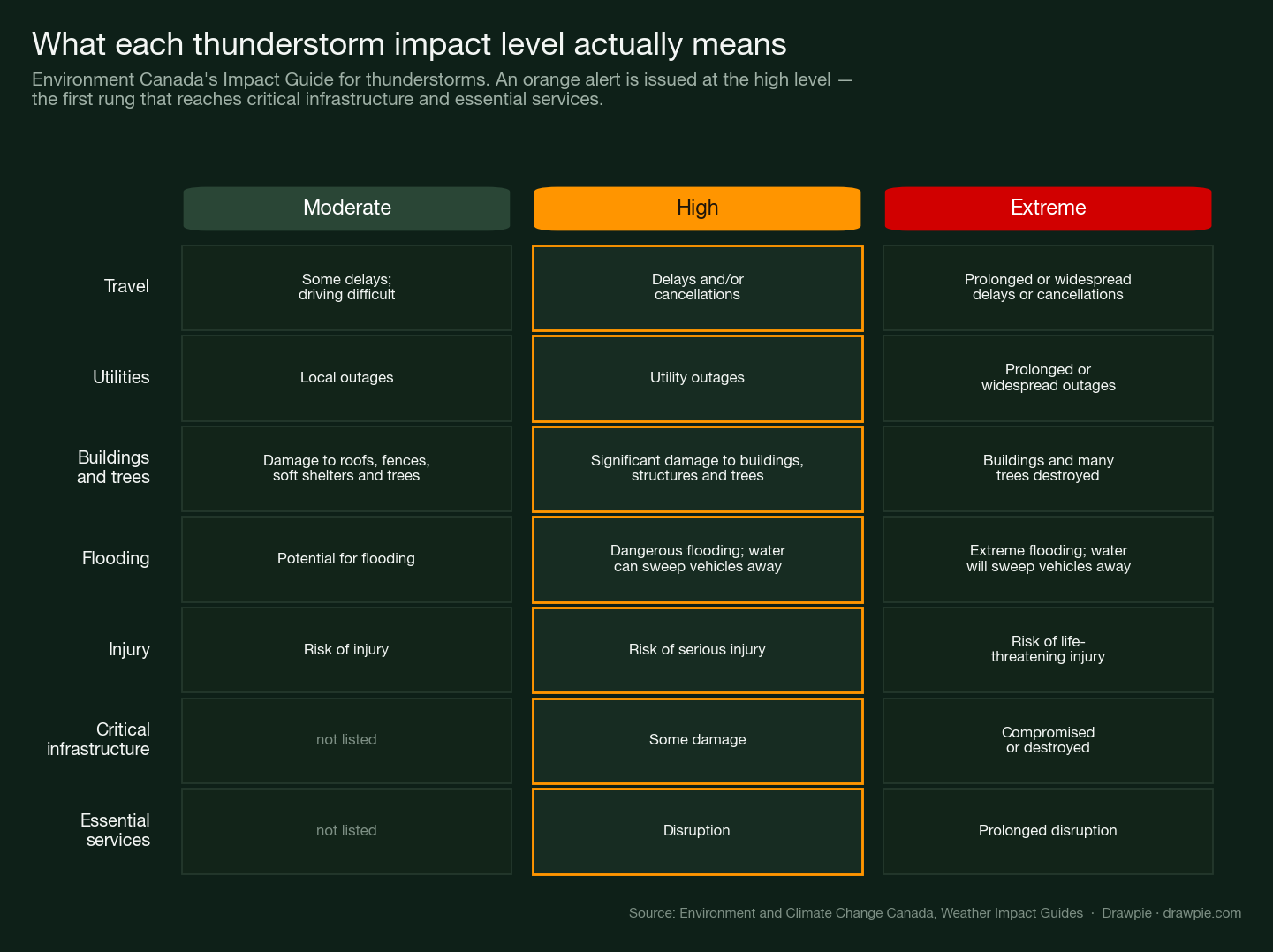
The impact guide behind the colour puts numbers on what “high” is supposed to look like: travel delays and cancellations, utility outages, significant damage to buildings and trees, dangerous flooding in which fast-moving water can sweep vehicles away, and a risk of serious injury. High is also the first level at which the guide reaches critical infrastructure damage and disruption to essential services. At the moderate level, those two categories are not listed at all.
How rare is an orange alert in Canada?
Environment Canada says orange alerts are uncommon, and a national snapshot taken at the time bears that out — though not in the way the raw count suggests.
Across all thirteen provinces and territories, 53 alerts were in force. Twenty-four were orange, which sounds like a lot until you notice that every one of them was this single Manitoba thunderstorm system spread across its 24 zones. Every other alert in the country — 26 yellow ones and three uncoloured weather statements — was a step below. In other words, one storm accounted for all of Canada’s orange alerts that night, and no red alert was in force anywhere.
When did Canada start using coloured weather alerts?
Environment Canada does not print a switch-on date, and it would be easy to invent one. What can be shown is narrower: the agency’s explainer page was already public on 26 November 2025, describing the system in the present tense, and it was last updated on 20 February 2026.
The agency still files the change under “New”, which fits the confusion the word orange is currently causing. The three alert types themselves did not change — warnings, advisories and watches are the same as they always were. What changed is that each one now arrives on a coloured banner, so the type tells you how urgently to act and the colour tells you how hard it is expected to hit.
What should you do when an orange severe thunderstorm watch is issued?
Treat it as a signal to prepare rather than a signal that nothing is happening yet. A watch means the ingredients are there; the warning, if it comes, may give you very little time.
Environment Canada’s standing advice for any thunderstorm is the simplest line it publishes: when thunder roars, go indoors. Lightning can occur with any thunderstorm, and it injures and kills Canadians every year. Beyond that, the practical steps for an orange-level thunderstorm follow from the impact guide — secure or bring in anything the wind can throw, move vehicles under cover if hail is forecast, avoid driving through water of unknown depth, and expect that power may go out.
The other thing the bulletin asks for is reports. Manitobans who see severe weather can email MBstorm@ec.gc.ca , call 1-800-239-0484, or post with #MBStorm. Those reports are what confirm whether a watch needs to become a warning.